Lac de Pannecière
| Lac de Pannecière | |
|---|---|
 | |
| Location | Nièvre |
| Coordinates | 47°09′15″N 3°53′44″E / 47.15417°N 3.89556°E |
| Type | artificial |
| Primary inflows | Yonne, Houssière, Ensein |
| Primary outflows | Yonne River |
| Basin countries | France |
| Max. length | 7.2 km (4.5 mi) |
| Max. width | 1 km (0.62 mi) |
| Surface area | 5.2 km2 (2.0 sq mi) |
| Max. depth | 48 m (157 ft) |
| Water volume | 82,500,000 m3 (2.91×10⁹ cu ft) |
| Residence time | 1 year |
| Surface elevation | 320 m (1,050 ft) |
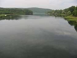
Lac de Pannecière is a lake in Nièvre, France. At an elevation of 320 m, its surface area is 5.2 km².
The construction of the dam was decided following major floods of the Seine, including that of 1910. The lake-reservoir was declared of public utility by a decree of the September 8, 1929.
Work Only actually began on September 29, 1937, but wasn't completed and was interrupted on WWII start, September 2, 1939. Work resumed in May 1946 and were completed in December 1949. During periods of high activity, up to 550 workers worked on the site (they were housed in a newly constructed workers' town, as the area has low population and most workers came from afar, without housing).
Two hamlets were engulfed during its impoundment of the reservoir: "Pelus" (entirely) and "Blaisy" (partially). Remains can still be seen during the annual partial emptying, or during the complete decennial emptying: piles of stone, the Yonne and the Houssière who find their bed and the old stone bridges spanning them, the roads that crossed the hamlets, etc.
Its construction also included the creation of 16 km of roads and 6 bridges.
A hydroelectric plant managed by EDF was set up in 1950. This plant takes advantage of the waterfall created by the dam to produce electricity.