Lac de Coiselet
| Lac de Coiselet | |
|---|---|
 | |
| Location | Ain/Jura |
| Coordinates | 46°19′40″N 5°37′00″E / 46.32778°N 5.61667°ECoordinates: 46°19′40″N 5°37′00″E / 46.32778°N 5.61667°E |
| Type | reservoir |
| Primary inflows | Ain, Bienne |
| Basin countries | France |
| Max. length | 6 km (3.7 mi) |
| Surface area | 3.8 km2 (1.5 sq mi) |
| Average depth | 9.5 m (31 ft) |
| Max. depth | 30 m (98 ft) |
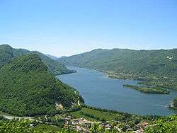
Lac de Coiselet is a reservoir on the border between the Ain and Jura departments in France. Its surface area is 3.8 km². The lake formed in 1970 after the Barrage de Coiselet was built at the confluence of the Ain and Bienne rivers.
External links

This article is issued from
Wikipedia.
The text is licensed under Creative Commons - Attribution - Sharealike.
Additional terms may apply for the media files.