Lašva
| Lašva | |
|---|---|
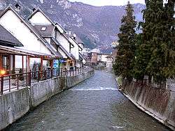 The Lašva in Travnik | |
| Country | Bosnia and Herzegovina |
| Physical characteristics | |
| Main source | Karaulska Lašva and Komarska Lašva |
| River mouth |
river Bosna, near Zenica 44°08′20″N 17°55′56″E / 44.1390°N 17.9323°ECoordinates: 44°08′20″N 17°55′56″E / 44.1390°N 17.9323°E |
| Length | 56.6 km (35.2 mi) [1] |
| Basin features | |
| Progression | Bosna→ Sava→ Danube→ Black Sea |
| Basin size | 958.1 km2 (369.9 sq mi) [1] |
The Lašva is a river in Central Bosnia, Bosnia and Herzegovina. It is a left tributary of the Bosna.[2][3][4][5]
It originates from the confluence of two "little Lašvas", Karaulska Lašva and Komarska Lašva in Turbe. The Lašva flows through Travnik, then through Vitez before draining into the Bosna.
See slso
| Wikimedia Commons has media related to Lašva_River. |
References
- 1 2 "Sava River Basin Analysis Report" (PDF, 9.98 MB). International Sava River Basin Commission. September 2009. p. 13. Retrieved 2018-05-18.
- ↑ http://www.kartabih.com/
- ↑ Vojnogeografski institut, Ed. (1955): Travnik (List karte 1:100.000, Izohipse na 20 m). Vojnogeografski institut, Beograd / Military Geographical Institute, Ed. (1955): Travnik (map sheet 1: 100,000, Contour lines at 20 m). Military Geographical Institute, Belgrade.
- ↑ Spahić M. et al. (2000): Bosna i Hercegovina (1:250.000). Izdavačko preduzeće „Sejtarija", Sarajevo., The Map
- ↑ Mučibabić B., Ed. (1998): Geografski atlas Bosne i Hercegovine. Geodetski zavod BiH, Sarajevo, ISBN 9958-766-00-0., pp: 4-5.
External links
This article is issued from
Wikipedia.
The text is licensed under Creative Commons - Attribution - Sharealike.
Additional terms may apply for the media files.