L'Île-d'Anticosti, Quebec
| L'Île-d'Anticosti | |
|---|---|
| Municipality | |
 | |
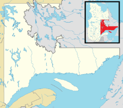 L'Île-d'Anticosti Location in Côte-Nord region of Quebec. | |
| Coordinates: 49°30′N 63°00′W / 49.500°N 63.000°WCoordinates: 49°30′N 63°00′W / 49.500°N 63.000°W[1] | |
| Country |
|
| Province |
|
| Region | Côte-Nord |
| RCM | Minganie |
| Constituted | January 1, 1984 |
| Government[2] | |
| • Mayor | John Pineault |
| • Federal riding | Manicouagan |
| • Prov. riding | Duplessis |
| Area[2][3] | |
| • Total | 9,291.18 km2 (3,587.34 sq mi) |
| • Land | 7,715.99 km2 (2,979.16 sq mi) |
| Population (2016)[4] | |
| • Total | 218 |
| • Density | 0.03/km2 (0.08/sq mi) |
| • Pop 2011-2016 |
|
| • Dwellings | 186 |
| Time zone | UTC−5 (EST) |
| • Summer (DST) | UTC−4 (EDT) |
| Postal code(s) | G0G 2Y0 |
| Area code(s) | 418 and 581 |
| Highways | No major routes |
| Website |
www |
L'Île d'Anticosti is a municipality in the Minganie Regional County Municipality in the Côte-Nord region of Quebec. Its territory coincides with Anticosti Island, a large island in the Gulf of Saint Lawrence.
Within the municipality, the main populated area is Port-Menier.
Officially the municipality was formed first in 1902 when Anticosti Island was separated from the County of Saguenay. But since the entire island was privately owned, there was no elected council to preside over the islanders, who were either servants of the landlord or employees of logging companies.[1] Even after the island was owned again by the provincial government in 1974, it took another decade to put a working municipal organization in place. On January 31, 1984, the first council was finally sworn in.[5]
Communities
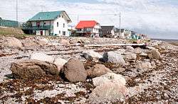
Port-Menier
The village of Port-Menier is the hub of the island. Its population doubles in the summer with seasonal workers and tourists. The economic mainstays are outdoor tourism and forestry/logging. Services available in Port-Menier are: general and grocery stores, gas station, banking, restaurant, and lodging.
Demographics
Population
| Canada census – L'Île-d'Anticosti, Quebec community profile | |||
|---|---|---|---|
| 2016 | 2011 | 2006 | |
| Population: | 218 (-9.2% from 2011) | 240 (-14.6% from 2006) | 281 (+5.6% from 2001) |
| Land area: | 7,953.20 km2 (3,070.75 sq mi) | 7,892.15 km2 (3,047.18 sq mi) | 7,892.15 km2 (3,047.18 sq mi) |
| Population density: | 0.0/km2 (0/sq mi) | 0.0/km2 (0/sq mi) | 0.0/km2 (0/sq mi) |
| Median age: | 53.0 (M: 55.6, F: 54.2) | 47.6 (M: 51.0, F: 46.3) | 42.2 (M: 45.5, F: 40.0) |
| Total private dwellings: | 186 | 161 | 144 |
| Median household income: | $56,704 | $.N/A | $48,970 |
| Notes: 2011 income data for this area has been suppressed for data quality or confidentiality reasons. – References: 2016[4] 2011[3] 2006[6] earlier[7] | |||
| Historical Census Data - L'Île-d'Anticosti, Quebec[8] | |||||||||||||||||||||||||||||
|---|---|---|---|---|---|---|---|---|---|---|---|---|---|---|---|---|---|---|---|---|---|---|---|---|---|---|---|---|---|
|
|
| |||||||||||||||||||||||||||
Language
| Canada Census Mother Tongue - L'Île-d'Anticosti, Quebec[8] | ||||||||||||||||||
|---|---|---|---|---|---|---|---|---|---|---|---|---|---|---|---|---|---|---|
| Census | Total | French |
English |
French & English |
Other | |||||||||||||
| Year | Responses | Count | Trend | Pop % | Count | Trend | Pop % | Count | Trend | Pop % | Count | Trend | Pop % | |||||
2016 |
215 |
210 | 97.67% | 5 | 2.33% | 0 | 0.00% | 0 | 0.00% | |||||||||
2011 |
240 |
235 | 97.92% | 5 | 2.08% | 0 | 0.00% | 0 | 0.00% | |||||||||
2006 |
280 |
280 | 100.00% | 0 | 0.00% | 0 | 0.00% | 0 | 0.00% | |||||||||
2001 |
280 |
260 | 92.86% | 10 | 3.57% | 0 | 0.00% | 10 | 3.57% | |||||||||
1996 |
265 |
265 | n/a | 100.00% | 0 | n/a | 0.00% | 0 | n/a | 0.00% | 0 | n/a | 0.00% | |||||
Time zone
Anticosti Island is bisected by the 63rd meridian west, and as a result, the eastern part of the municipality is officially within the AST legislated time zone boundary. However, in practice, all of L'Île-d'Anticosti observes the Eastern Time Zone (EST and EDT).[9]
Education
Commission scolaire du Littoral operates St-Joseph School (francophone) in Port-Menier.[10]
See also
References
- 1 2 Reference number 177366 of the Commission de toponymie du Québec (in French)
- 1 2 "L'Île-d'Anticosti". Répertoire des municipalités (in French). Ministère des Affaires municipales, des Régions et de l'Occupation du territoire. Retrieved 2018-07-10.
- 1 2 "2011 Community Profiles". Canada 2011 Census. Statistics Canada. July 5, 2013. Retrieved 2013-04-03.
- 1 2 "2016 Community Profiles". Canada 2016 Census. Statistics Canada. February 21, 2017. Retrieved 2018-07-10.
- ↑ "Histoire d'Anticosti" (in French). Municipalité de L'Île-d'Anticosti. Retrieved 2009-11-05.
- ↑ "2006 Community Profiles". Canada 2006 Census. Statistics Canada. March 30, 2011. Retrieved 2013-04-03.
- ↑ "2001 Community Profiles". Canada 2001 Census. Statistics Canada. February 17, 2012.
- 1 2 Statistics Canada: 1996, 2001, 2006, 2011, 2016 census
- ↑ National Research Council Canada - Time Zones & Daylight Saving Time Archived 2010-03-17 at the Wayback Machine.
- ↑ "Schools and centers." Commission scolaire du Littoral. Retrieved on September 23, 2017.
Adjacent Municipal Subdivisions | |
|---|---|
| Municipalities | |
|---|---|
| Townships | |
| Unorganized Territories | |
| Native reserves (Unassociated with RCM) | |
| |