Kutsujima, Kyoto
| Native name: 沓島 Kutsujima Nickname: Kojima | |
|---|---|
 | |
 Kutsujima Island Location in Japan | |
| Geography | |
| Location | Sea of Japan |
| Coordinates | 35°42′40″N 135°26′16″E / 35.71111°N 135.43778°ECoordinates: 35°42′40″N 135°26′16″E / 35.71111°N 135.43778°E |
| Archipelago | yes |
| Total islands | 2 |
| Major islands | 2 |
| Area | 0.0097 km2 (0.0037 sq mi) |
| Length | 0.6 km (0.37 mi) |
| Width | 0.05 km (0.031 mi) |
| Highest elevation | 89 m (292 ft) |
| Highest point | Bell Rock |
| Administration | |
|
Japan | |
| Prefecture | Kyoto Prefecture |
| City | Maizuru |
| Demographics | |
| Population | 0 |
| Ethnic groups | Japanese |
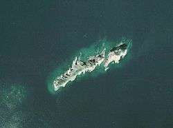
Kutsujima (沓島 Kutsu-jima) is a volcanic island in the Sea of Japan, 2.5 km from the coast of the Kyoto Prefecture in Japan. Kutsujima Island is administered as part of Maizuru city. The island consist of two islets - the smaller northern (where highest elevation rocks are located) is Tsurigane-jima (釣鐘島) or Meshima (女島) and larger southern is Bōshima (棒島) or Kojima (小島)
According to inscriptions on Tango no kuni fudoki, the Kanmurijima and Kutsujima are the remains of the much larger island which submerged following an earthquake in 701 A.D. The topography of seafloor seems to support the claim, as the steep 60-meters cliff is located underwater off eastern coast of Kanmurijima and Kutsujuma, indicating a recent crustal fault. The northern islet is inaccessible without rock-climbing equipment,[1] and was the famous hermits prayer location during the late 19th century. Currently, the islets are designated as Kanmurijima-Kutsujima wildlife protection area area and any landing is prohibited.
See also
- This article incorporates material from Japanese Wikipedia page 沓島, accessed 5 January 2017
- Kanmurijima