Kuruppampady
| Kuruppampady | |
|---|---|
| town | |
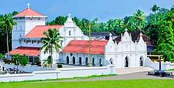 Kuruppampady Pally | |
 Kuruppampady Location in Kerala, India  Kuruppampady Kuruppampady (India) | |
| Coordinates: 10°06′45″N 76°31′00″E / 10.1125°N 76.5166°ECoordinates: 10°06′45″N 76°31′00″E / 10.1125°N 76.5166°E | |
| Country |
|
| State | Kerala |
| District | Ernakulam |
| Languages | |
| • Official | Malayalam, English |
| Time zone | UTC+5:30 (IST) |
| PIN | 683545 |
| Telephone code | 0484 |
| Vehicle registration | KL-40 |
| Nearest city | Cochin |
| Lok Sabha constituency | Chalakkudy |
Kuruppampady is situated about five kilometers from Perumbavoor on the Aluva-Munnar road, in Kunnathunadu Taluke, Ernakulam district, Kerala, India.
Location
| |||||||||||||
It is surrounded by important places viz. Perumbavoor, Kalady, Malayattoor, Angamaly, Aluva, Muvattupuzha, Odakkaly, Kallil, Iringole kavu (miniature forest), Kolencherry, Kottapady, Kothamangalam, Alattuchira, Vengoor, Kombanad, Panamkuzhy, Poru, Vengola, Paniyely, Kodanad, Kurichilakode and so on and so forth within 20 kilometers circle. Kuruppampady is also famous for its lemon grass production for about a century. The town has a well known temples Iricvichira siva temple and kootumadhom temple.The famous churches are St. Marys Jacobite Syrian Cathedral, more commonly known as Kuruppampady Palli. Kerala Vyapari Vyavasayi ekopana Samithi office,Kuruppampady private bus stand,court,District institutional training centre for teachers DIET,krishna hospital,hotel hamilton international,koovapady block office,mini industrial village,tech steel industries,bank of India,federal bank,south Indian bank,dhanalaxmi bank,state bank of India etc. are the important landmarks in town.
The important private business centers are bread and butter bake house,city bakers,sobha electricals,jose jwellerrs,choice gift house,etc
| Wikimedia Commons has media related to Kuruppampady. |