Cuncapata
| Cuncapata | |
|---|---|
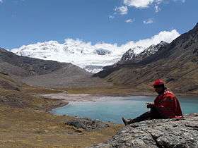 Chumpi (on the left) and Cuncapata (on the right) behind the lake Sibinacocha | |
| Highest point | |
| Elevation | 5,400 m (17,700 ft) [1] |
| Coordinates | 13°45′45″S 71°03′37″W / 13.76250°S 71.06028°WCoordinates: 13°45′45″S 71°03′37″W / 13.76250°S 71.06028°W |
| Geography | |
 Cuncapata | |
| Parent range | Andes, Vilcanota |
Cuncapata (possibly from Aymara kunka throat, pata step,[2] Quechua kunka throat, pata elevated place / above, at the top / edge, bank (of a river), shore,[3][4]) is a mountain in the Vilcanota mountain range in the Andes of Peru, about 5,400 metres (17,717 ft) high. It is located in the Cusco Region, Canchis Province, Pitumarca District. Cuncapata lies southwest of the mountain Jatunñaño Punta, north of the lake Sibinacocha and southeast of Chumpe.[1]
References
- 1 2 escale.minedu.gob.pe - UGEL map of the Quispicanchi Province 1 (Cusco Region)
- ↑ Radio San Gabriel, "Instituto Radiofonico de Promoción Aymara" (IRPA) 1993, Republicado por Instituto de las Lenguas y Literaturas Andinas-Amazónicas (ILLLA-A) 2011, Transcripción del Vocabulario de la Lengua Aymara, P. Ludovico Bertonio 1612 (Spanish-Aymara-Aymara-Spanish dictionary)
- ↑ Teofilo Laime Ajacopa, Diccionario Bilingüe Iskay simipi yuyayk'ancha, La Paz, 2007 (Quechua-Spanish dictionary)
- ↑ Diccionario Quechua - Español - Quechua, Academía Mayor de la Lengua Quechua, Gobierno Regional Cusco, Cusco 2005 (Quechua-Spanish dictionary)
This article is issued from
Wikipedia.
The text is licensed under Creative Commons - Attribution - Sharealike.
Additional terms may apply for the media files.