Kuma–Manych Depression
Kuma–Manych Depression
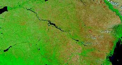
Kuma-Manych Depression and Manych River from space.
Upper left is the eastern tip of the Sea of Azov and lower right is the Caspian Sea. In the middle of the image is the Lake Manych-Gudilo.
Upper right is the Volga and lower left is the Kuban River.
Upper left is the eastern tip of the Sea of Azov and lower right is the Caspian Sea. In the middle of the image is the Lake Manych-Gudilo.
Upper right is the Volga and lower left is the Kuban River.
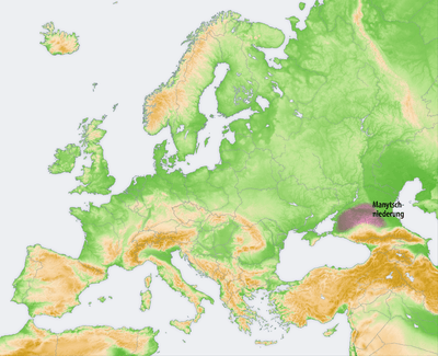
The Kuma–Manych Depression (Russian: Кумо–Манычская впадина, tr. Kumo–Manychskaya vpadina), is a geological depression in southwestern Russia that separates the Russian Plain to the north from Ciscaucasia to the south.[1] It is named after the Kuma and Manych rivers.[2]
It is sometimes regarded as a definition for the natural boundary between Europe and Asia,[1][3] although some modern sources use the Greater Caucasus watershed instead.
The Rostovsky Biosphere Reserve is located within the Depression.[4]
See also
References
- 1 2 "'Kuma-Manych Depression'. Encyclopædia Britannica. Encyclopædia Britannica Online". Encyclopædia Britannica Inc., 2015. Retrieved 3 December 2015.
- ↑ Microsoft Encarta World Atlas, 2001, Microsoft Corporation
- ↑ "3. The continent - Extent and boundaries". Europe's Environment - The Dobris Assessment. European Environmental Agency. 2011.
- ↑ "Rostovsky". The MAB Programme. UNESCO. 14 January 2010. Retrieved 7 December 2013.
Coordinates: 45°42′54″N 44°06′18″E / 45.71500°N 44.10500°E
This article is issued from
Wikipedia.
The text is licensed under Creative Commons - Attribution - Sharealike.
Additional terms may apply for the media files.