Krzywiń
| Krzywiń | |||
|---|---|---|---|
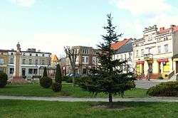 Market square | |||
| |||
 Krzywiń | |||
| Coordinates: 51°58′N 16°49′E / 51.967°N 16.817°E | |||
| Country |
| ||
| Voivodeship | Greater Poland | ||
| County | Kościan | ||
| Gmina | Krzywiń | ||
| Area | |||
| • Total | 1.67 km2 (0.64 sq mi) | ||
| Highest elevation | 75 m (246 ft) | ||
| Lowest elevation | 67 m (220 ft) | ||
| Population (2006) | |||
| • Total | 1,547 | ||
| • Density | 930/km2 (2,400/sq mi) | ||
| Postal code | 64-010 | ||
Krzywiń [ˈkʂɨvʲiɲ] (German: Kriewen) is a small town in the centre of Poland in the Kościan County, Greater Poland Voivodeship, located at the Obra canal.
Krzywiń was first referred to in scripts as Crivin in 1181. But it was not until 1237 that the area's reputation grew as a prominent marketplace. It was then that it was referred to as a town. Incorporation of the town followed in 1257.[1]
There are three schools in Krzywiń. There is a primary school, a junior high school and a high school.
External links
References
Coordinates: 51°57′35″N 16°49′10″E / 51.95972°N 16.81944°E
| Wikimedia Commons has media related to Krzywiń. |
| Town and seat |  | |
|---|---|---|
| Villages | ||
This article is issued from
Wikipedia.
The text is licensed under Creative Commons - Attribution - Sharealike.
Additional terms may apply for the media files.