Krotoszyn
| Krotoszyn | |||
|---|---|---|---|
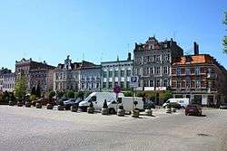 Market Square | |||
| |||
 Krotoszyn | |||
| Coordinates: 51°41′N 17°26′E / 51.683°N 17.433°ECoordinates: 51°41′N 17°26′E / 51.683°N 17.433°E | |||
| Country |
| ||
| Voivodeship | Greater Poland | ||
| County | Krotoszyn County | ||
| Gmina | Gmina Krotoszyn | ||
| Established | 15th century | ||
| Town rights | 1415 | ||
| Government | |||
| • Mayor | Franciszek Marszałek | ||
| Area | |||
| • Total | 22.55 km2 (8.71 sq mi) | ||
| Highest elevation | 140 m (460 ft) | ||
| Lowest elevation | 130 m (430 ft) | ||
| Population (2006) | |||
| • Total | 29,421 | ||
| • Density | 1,300/km2 (3,400/sq mi) | ||
| Time zone | UTC+1 (CET) | ||
| • Summer (DST) | UTC+2 (CEST) | ||
| Postal code | 63–700 to 63–710 | ||
| Area code(s) | +48 62 | ||
| Car plates | PKR | ||
| Climate | Cfb | ||
| Website | http://www.krotoszyn.pl | ||


Krotoszyn [krɔˈtɔʂɨn] (German: Krotoschin, Yiddish: קארטשין Kortshin) is a town in central Poland with 30,010 inhabitants as of 2005. It has been part of the Greater Poland Voivodeship since 1999; it was within Kalisz Voivodeship from 1975 to 1998.
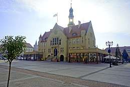
Historically part of the Kingdom of Poland, during the German rule in the 19th century after the Partitions of Poland, the town was located in the Prussian province of Posen. The dominant trade is in grain and seeds, and the headquarters of the Polish branch of Mahle GmbH is located there. The castle of Krotoszyn was the centre of a mediatized principality formed in 1819 out of the holdings of the Prussian crown and granted to the prince of Thurn und Taxis in compensation for his relinquishing control over the Prussian postal system.
Notable people
- Katarzyna Grochola – Famous Polish writer
- Sir John Monash – Australian general
- Georg Huth – German Orientalist
- Isidor Kalisch – Reform rabbi.
- Theodor Kullak – Pianist and composer.
- Marian Langiewicz – A military leader of the January Uprising.
- Marcin Lijewski – Handballer
- Otto Roquette (1824–1896) – German author
- Maria Siemionow - World renowned scientist and microsurgeon.
- Melitta von Stauffenberg (born Schiller) – famous German test pilot of WWII
- David Zvi Banet (1893–1973) – Orientalist and Professor of Arabic Studies at the Hebrew University in Jerusalem
International relations
Twin towns – Sister cities
Krotoszyn is twinned with:


References

- Mangabay Population Listing
| Seat |  | |
|---|---|---|
| Urban gmina | ||
| Urban-rural gminas | ||
| Rural gmina | ||
| Wikimedia Commons has media related to Krotoszyn. |