Krasnoyarsk Dam
| Krasnoyarsk Dam | |
|---|---|
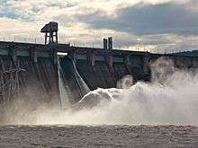 The dam with one of the spillways open. | |
 Location of Krasnoyarsk Dam in Russia | |
| Location | Divnogorsk, Russia |
| Coordinates | 55°56′05″N 92°17′37″E / 55.93472°N 92.29361°ECoordinates: 55°56′05″N 92°17′37″E / 55.93472°N 92.29361°E |
| Construction began | 1956 |
| Opening date | 1972 |
| Dam and spillways | |
| Type of dam | Gravity dam |
| Impounds | Yenisey River |
| Height | 124 m (407 ft) |
| Length | 1,065 m (3,494 ft) |
| Reservoir | |
| Creates | Krasnoyarsk Reservoir |
| Total capacity | 73.3 km3 (17.6 cu mi) |
| Surface area | 2,000 km2 (772 sq mi) |
| Power Station | |
| Installed capacity | 6,000 MW |
The Krasnoyarsk Dam is a 124-metre (407 ft) high concrete gravity dam located on the Yenisey River about 30 kilometres (19 mi) upstream from Krasnoyarsk in Divnogorsk, Russia. It was constructed from 1956 to 1972, and it supplies about 6,000 MW (six GW) of power, mostly used to supply the KrAZ (Krasnoyarsky Aluminievyy Zavod, the Krasnoyarsk Aluminum Plant). Both power and aluminum plants are controlled by the RUSAL company.

Beginning with the opening of the 10th turbine in April 1971, the powerhouse was the world’s single largest power plant until the Grand Coulee Dam in [Washington State]] reached 6,181 MW in 1983. The Krasnoyarsk Dam is held to be a landmark symbol of Krasnoyarsk, and it is depicted on the 10-ruble banknote.
As a result of the damming, the Krasnoyarsk Reservoir was created. This reservoir, informally known as the Krasnoyarsk Sea, has an area of 2,000 square kilometres (770 sq mi) and a volume of 73.3 cubic kilometres (18 cu mi). It is 388 km (241 mi) in length and 15 km (9 mi) in width at its widest, has an average depth of 36.6 m (120.1 ft), and a depth of 105 m (344 ft) near the dam.[1]
The Krasnoyarsk Dam significantly influences the local climate; normally the river would freeze over in the bitterly-cold Siberian winter, but because the dam releases unfrozen water year-round, the river never freezes in the 200 kilometres (120 mi) to 300 kilometres (190 mi) stretch of river immediately downstream from the dam.[2][3] In winter, the frigid air interacts with the warm river water to produce fog, which shrouds Krasnoyarsk and other downstream areas.[3][4]
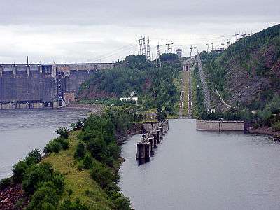
The dam is equipped with a canal inclined plane to allow passage of ships. It is in fact an electric rack railway. The track gauge is 9,000 mm (29 ft 6 5⁄16 in), making it the widest-gauge railway of any type in the world.[5] At the time of its construction, this feat of modern engineering allowed for ships to be physically moved in only 90 minutes.
See also
References
- ↑ "Krasnoyarkkoye Reservoir". International Lake Environment Committee. Archived from the original on July 23, 2011. Retrieved 24 July 2011.
- ↑ Grigor'ev, Yu. A.; Sokol'nikov, N. M. (October 1973). "Ice-thermal reservoir regimen during first years of operation of the Krasnoyarsk hydroelectric plant". Hydrotechnical Construction. 7 (10): 30–32. doi:10.1007/BF02377727. Retrieved 21 September 2013.
- 1 2 "Hydroelectric Dams: A Looming Threat to Russia's Mighty Rivers". Pacific Environment. Retrieved 21 September 2013.
- ↑ Gotlib, Ya. L. (December 1996). "Possible improvement of the ice and thermal conditions in the lower pool of the Krasnoyarsk hydroelectric station". Hydrotechnical Construction. 30 (12): 26–28. doi:10.1007/BF02447466. Retrieved 21 September 2013.
- ↑ "Archived copy". Archived from the original on 2014-04-07. Retrieved 2014-06-29.
External links
| Wikimedia Commons has media related to Krasnoyarsk Dam. |
- Yenisey River Steam Navigation (in Russian) - photo gallery showing ship elevator
- Singl Russian shiplift/Единственный в России судоподъемник - Video of the ship elevator in operation