Hrvatska Kostajnica
| Hrvatska Kostajnica | |
|---|---|
| Town | |
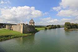 Hrvatska Kostajnica Castle and Una River | |
 Hrvatska Kostajnica Location in Croatia | |
| Coordinates: 45°14′N 16°32′E / 45.233°N 16.533°E | |
| Country |
|
| County |
|
| Government | |
| • Mayor | Dalibor Bišćan (HDZ) |
| Population (2011)[1] | |
| • Total | 2,756 |
| Time zone | UTC+1 (CET) |
| • Summer (DST) | UTC+2 (CEST) |
| Website | Grad Hrvatska Kostajnica |
Hrvatska Kostajnica (Croatian pronunciation: [xř̩ʋaːtskaː kǒstaːjnit͡sa] in German Castanowitz, in Italian Costainizza), often just Kostajnica, is a small town in central Croatia. It is located on the Una river in the Sisak-Moslavina County, south of Petrinja and Sisak and across the river from Bosanska Kostajnica in Bosnia and Herzegovina.
History
Kostajnica was first mentioned in the document by knights templar from 1240. This year is used as official birth year of this historic town.
Time of the first settlement is unknown, but town lies on very important Roman roads that were used for transporting salt and cotton. Since Roman roads were merged in the vicinity of the city it is believed that settlement dates much earlier than the first written document known today. Position of town is very similar to the town from old Roman documents known as “Oeneum”. Five Roman milestones were located in the city dating back to the 3rd century A.D.
During 13th and 14th century Kostajnica became a fortification (kaštel) that was built as a protection against invading Turks. The owners of the fortification were members of the noble families Lipovečki, Tot, Frankopan, Benvenjud and finally Zrinski, so the castle is today known as Zrinski castle (Stari grad Zrinski in Croatian). Other forts existing during that period were in the surrounding villages of Komogovina, Svinica, and Prevršac. After, Commander of the Hrvatska Kostajnica was Prince and Duke Luke Novosel of Transleithania (House of Novosel) (Croatia and Slavonia part). The Turks invaded Kostajnica in 1556 and it wasn't until 1687 that the town was liberated.
During the early 18th century two schools are opened in the city. One school was operated by Catholic Missionary Church of “St. Antun Padovinski”, while the second schools was run as a Serbian Public School. Kostajnica is known for its natural springs such as; Varoški Bunar, Mrzlenac, Tekija, Pekinac, Paunovac, Angelovac, and Tutulovac. The most popular spring Tekija has engraved sign (drink brother, potion was given to you by the god’s mercy) “Pi brate iz Božje milosti dat ti je napitak.”
In the late 19th and early 20th century, Kostajnica was a district capital in the Zagreb County of the Kingdom of Croatia-Slavonia.
During World War II Hrvatska Kostajnica was bombed by American forces on May 30, 1944.
Kostajnica suffered greatly during the Croatian War of Independence. A large part of the Croatian population were expelled or killed by rebel Serbs in 1991 and the city was incorporated into the Republic of Serbian Krajina. Houses and buildings belonging to Croats were burned and looted, including the baroque church, the medieval apothecary, and the eighteenth-century Franciscan monastery. The only piece of the city's cultural heritage left was the castle by the river built by the Frankopans. Kostajnica was put back in Croatian control following military victories by the army in August 1995, and the Croat population expelled slowly began returning.
Population
The municipality population of 2,756 is composed of the following settlements:[1]
In the 2011 population census, Croats made up 69.34% of the municipal population and Serbs were 25.04%.[2]
Population of Hrvatska Kostajnica town by ethicity[3][4][5]
| Year of census | total | Croats | Serbs | Yugoslavs | others |
|---|---|---|---|---|---|
| 2011 | 2 756 | 1 911 (69.34%) | 690 (25.04%) | - | 155 (5.62%) |
| 2001 | 2 746 | 2 115 (77.02%) | 433 (15.77%) | - | 198 (7.21%) |
| 1991 | 3 480 | 1 087 (31.23%) | 1 889 (54.28%) | 264 (7.58%) | 240 (6.89%) |
| 1981 | 3 159 | 1 023 (32.38%) | 1 374 (43.49%) | 639 (20.22%) | 123 (3.89%) |
| 1971 | 2 431 | 1 120 (46.07%) | 1 104 (45.41%) | 110 (4.52%) | 97 (3.99%) |
Economy
Today, chief occupations are farming, leather (footwear), textiles plant, printing, and wood processing mill. Fishing and hunting are very important tourist attractions in the city with some of the best natural habitats found in this part of Europe. Hrvatska Kostajnica is underdeveloped municipality which is statistically classified as the First Category Area of Special State Concern by the Government of Croatia.[6]
Notable natives and residents
- Svetozar Boroević (1856-1920) - Austro-Hungarian Field Marshal
- Milislav Demerec (1895-1966) - geneticist, former director of the Cold Spring Harbor Laboratory
- Adam Pribićević (1880-1957) - publisher, writer, and politician
- Milan Pribićević (1877-1937) - politician
- Svetozar Pribićević (1875-1936) - politician
- Antun Vakanović (1808-1894) - politician and Ban of Croatia
- Nikola Nina Maraković (1912—1943) - antifascist and People's Hero of Yugoslavia
References
- Tanner, Marcus, Croatia: Yale University Press, 1997.
- 1 2 "Population by Age and Sex, by Settlements, 2011 Census: Hrvatska Kostajnica". Census of Population, Households and Dwellings 2011. Zagreb: Croatian Bureau of Statistics. December 2012.
- ↑ "Population by Ethnicity, by Towns/Municipalities, 2011 Census: County of Sisak-Moslavina". Census of Population, Households and Dwellings 2011. Zagreb: Croatian Bureau of Statistics. December 2012.
- ↑ Izdanje Državnog zavoda za statistiku RH: Narodnosni sastav stanovništva RH od 1880-1991. godine.
- ↑ "Population by Ethnicity, by Towns/Municipalities, 2001 Census: County of Sisak-Moslavina"
- ↑ "Population by Ethnicity, by Towns/Municipalities, 2011 Census: County of Sisak-Moslavina"
- ↑ Lovrinčević, Željko; Davor, Mikulić; Budak, Jelena (June 2004). "AREAS OF SPECIAL STATE CONCERN IN CROATIA- REGIONAL DEVELOPMENT DIFFERENCES AND THE DEMOGRAPHIC AND EDUCATIONAL CHARACTERISTICS". Ekonomski pregled, Vol.55 No.5-6. Retrieved 25 August 2018.
External links
Subdivisions of Sisak-Moslavina County | ||
|---|---|---|
| Cities and towns | ||
| Municipalities | ||