Komáří hůrka
| Komáří hůrka | |
|---|---|
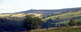 Blick zum Mückenberg von Norden | |
| Highest point | |
| Elevation | 807.5 m n.m. (2,649 ft) |
| Coordinates | 50°42′24″N 13°51′24″E / 50.70667°N 13.85667°ECoordinates: 50°42′24″N 13°51′24″E / 50.70667°N 13.85667°E |
| Geography | |
 Komáří hůrka | |
| Parent range | Ore Mountains |
| Geology | |
| Mountain type | biotite gneiss with tin ore deposits |
| Climbing | |
| Access | 1568 by the tin mining industry |
Komáří hůrka (German: Mückenberg) is one of the highest mountains in the Eastern Ore Mountains on the territory of the Czech Republic.
Location and surroundings
Komáří hůrka lies northeast of Krupka (Graupen) and southeast of Cínovec (Böhmisch Zinnwald) immediately on the steepest section of the Ore Mountain escarpment. As a result, it is a good observation point, from which there are views in almost all directions of the compass. In addition the characteristic appearance of a fault block mountain range with its steep escarpment falling away to the south is very clearly seen from this part of the Ore Mountains.
Historic photo gallery
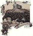 View around 1896
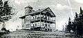 View around 1904
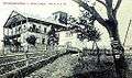 View around 1908
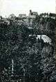 Around 1918
External links
| Wikimedia Commons has media related to Komáří hůrka. |
This article is issued from
Wikipedia.
The text is licensed under Creative Commons - Attribution - Sharealike.
Additional terms may apply for the media files.