Kladorub
| Kladorub | |
|---|---|
 Kladorub Location of Kladorub | |
| Coordinates: 43°42′N 22°42′E / 43.700°N 22.700°E | |
| Country |
|
| Provinces (Oblast) | Vidin |
| Government | |
| • Mayor | Todor Todorov |
| Elevation | 193 m (633 ft) |
| Population (2008) | |
| • Total | 49 |
| Time zone | UTC+2 (EET) |
| • Summer (DST) | UTC+3 (EEST) |
| Postal Code | 3758 |
| Area code(s) | 09341 |
Kladorub (Bulgarian: Кладоруб [kladoˈrub]) is a village in northwestern Bulgaria.
It is located in Vidin region, Dimovo Municipality.
Geography
Archar river floats near the village.
History
Kladorub lies upon the remains of an ancient village. The name of that village - Conbustica, is marked on the Roman road map Tabula Peutengiriana as a point, located on the road from Ratiaria (current Archar) to Naisos (current Niš).
Thare also lies the remains of an ancient Roman war camp. There, in the first years of the Roman occupation, a stone fortification had been built.
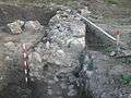 Wall of a Roman camp
Lots of Roman ceramics and metal objects have been found in excavations near the village.
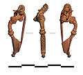 Fibula from the 2nd century
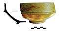 Roman ceramics
Cultural and Natural sights
The Magura cave is located 6 kilometers west of the village.
The Belogradchik rocks are located 18 kilometers from Kladorub.
Honour
Kladorub Glacier on Nordenskjöld Coast in Graham Land, Antarctica is named after the village.