Kirrberg (Saar)
| Kirrberg | ||
|---|---|---|
| Stadtteil of Homburg | ||
 View of Kirrberg | ||
| ||
 Kirrberg | ||
| Coordinates: 49°18′1″N 7°22′10″E / 49.30028°N 7.36944°ECoordinates: 49°18′1″N 7°22′10″E / 49.30028°N 7.36944°E | ||
| Country | Germany | |
| State | Saarland | |
| District | Saarpfalz | |
| Municipality | Homburg | |
| Population (1 October 2017) | ||
| • Total | 2,770 | |
| Time zone | CET/CEST (UTC+1/+2) | |
| Postal codes | 66424 | |
| Dialling codes | 06841 | |
| Vehicle registration | HOM | |
| Website | Official website | |

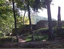
Ruins of the Merburg
Kirrberg (in dialect Kerrbrich) is a district of Homburg, situated in the eastern part of the Saarpfalz (Saar-Palatinate) district and the Saarland bordering state Rhineland-Palatinate. Until End 1973 was Kirrberg an independent municipality in the former Homburg district. Homburg (5 km), Zweibrücken (7 km), Saarbrücken and Kaiserslautern (both 35 km) are the closest towns. As of October 1, 2017, 2,770 inhabitants live in Kirrberg.
The river Lambsbach runs through the district from east to west.
History
The chapel of Kirrberg was firstly mentioned in the year 1290 as "Capella in Kirchperch". On 23 April 1949 Kirrberg was affiliated to the Bundesland Saarland and because of that it is the youngest village of the Bundesland.
External links
| Authority control |
|---|
This article is issued from
Wikipedia.
The text is licensed under Creative Commons - Attribution - Sharealike.
Additional terms may apply for the media files.