Kionga Triangle
| Kionga Triangle Kionga-Dreieck | |||||||||
|---|---|---|---|---|---|---|---|---|---|
| 1894–1916 | |||||||||
  | |||||||||
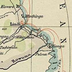 Kionga-Triangle in an old German map (lower right side) | |||||||||
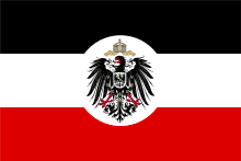
| Status | German colony | ||||||||
| Common languages | Portuguese | ||||||||
| Kaiser (German Emperor) | |||||||||
• 1894–1916 | Wilhelm II (r. 1888–1918) | ||||||||
| Governor of German East Africa | |||||||||
• 1894–1895 (first) | Friedrich von Schele (from 1893) | ||||||||
• 1912–1916 (last) | Heinrich Schnee (to 1918) | ||||||||
| Historical era | New Imperialism | ||||||||
|
26 February 1885 | |||||||||
|
16 June 1894 | |||||||||
• Germany entered World War I | 1 August 1914 | ||||||||
• Portuguese troops sent to Mozambique, partly tasked to recapture Kionga |
November 1915 | ||||||||
|
23 February 1916 | |||||||||
|
9 March 1916 | |||||||||
• German forces evacuate Kionga | 9 April 1916 | ||||||||
• Portuguese troops recapture Kionga | 10 April 1916 | ||||||||
|
25 September 1919 | |||||||||
| Area | |||||||||
| 1910 | 1,000 km2 (390 sq mi) | ||||||||
| Population | |||||||||
• 1910 | 4000 | ||||||||
| Currency | German East African rupie | ||||||||
| |||||||||
| Today part of |
| ||||||||
Coordinates: 10°35′46″S 40°30′32″E / 10.596°S 40.509°E
The Kionga Triangle (German: Kionga-Dreieck, Portuguese: Triângulo de Quionga) was a small area of land on the south-east coast of Africa. It lay between the colonies of German East Africa, the major part of present-day Tanzania, and Portuguese Mozambique, the present-day country of Mozambique. The area covered just 1,000 square kilometres (390 sq mi), and the settlement of Kionga — now spelled Quionga — had a population of 4,000 people in 1910. The triangle was a German possession from 1894 to 1916, after which it became a possession of Portugal.
History
An 1886 provisional agreement between Germany and Portugal designated the Ruvuma River as the border between the colonies. The Germans, however, established an outpost south of the Ruvuma River in 1894, and had thus encroached upon Portuguese territory. On 9 March 1916 during World War I, Germany declared war on Portugal. The Portuguese military seized the disputed area in April 1916.[1] The post-war Treaty of Versailles reaffirmed that the river was the border between Tanganyika, now under British control, and Portuguese Mozambique. The triangle was the only territory that the treaty awarded to Portugal.
Since Mozambique became independent on 25 June 1975, the Kionga Triangle has been a part of Cabo Delgado Province.
Postage stamps
Postage stamps were issued for Kionga during the German occupation.
References
- ↑ Hew Strachan (2004). The First World War in Africa. Oxford University Press. p. 161. ISBN 9780199257287. Retrieved 21 September 2017.
Further reading
- Thomas, H. B., "The Kionga Triangle", Tanganyika Notes and Records Volume 31 1951, pages 47-50.
External links
| Colonies |
| |||||
|---|---|---|---|---|---|---|
| Concessions |
| |||||
| Unrecognised |
| |||||