Kinpurnie Hill
| Kinpurnie Hill | |
|---|---|
.jpg) | |
| Highest point | |
| Elevation | 345 m (1,132 ft) |
| Listing | Marilyn |
| Coordinates | 56°33′46″N 3°06′14″W / 56.5627°N 3.1039°WCoordinates: 56°33′46″N 3°06′14″W / 56.5627°N 3.1039°W |
| Geography | |
| Location | Angus, Scotland |
| Parent range | Sidlaw Hills |
| Topo map | OS Landranger 53 |
| Climbing | |
| Easiest route | Follow grass path to summit |
Kinpurnie Hill is one of the most famous hills of the Sidlaw range in south-east Perthshire. At an elevation of 345 metres (1,132 ft), it is classified as a Marilyn.
Kinpurnie Hill is located near Newtyle and is popular with hillwalkers.
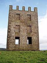
Kinpurnie Tower observatory on Kinpurnie Hill
Kinpurnie Tower
Atop the hill is Kinpurnie Tower, built by amateur astronomer James Stuart-Mackenzie in 1766. It is 6 metres (20 ft) tall and is visible from the roadside.
The observatory was designed by Alexander Bryce (1713 - 1786), Minister of Kirknewton and East Calder, but remained incomplete.
References
This article is issued from
Wikipedia.
The text is licensed under Creative Commons - Attribution - Sharealike.
Additional terms may apply for the media files.