Kilitbahir
| Kilitbahir | |
|---|---|
| Village | |
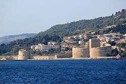 Kilitbahir Castle, built by Mehmed II Fatih in 1452 | |
 Location of the municipality of Eceabat within Turkey | |
 Kilitbahir Location in Turkey | |
| Coordinates: 40°08′55″N 26°22′45″E / 40.14861°N 26.37917°ECoordinates: 40°08′55″N 26°22′45″E / 40.14861°N 26.37917°E | |
| Country |
|
| Region | Marmara |
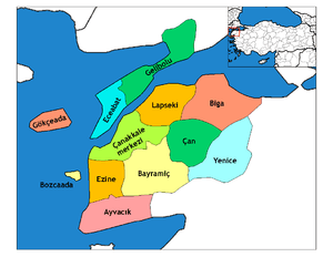
| Province | Çanakkale |
| Municipality | Eceabat |
| Time zone | UTC+2 (EET) |
| • Summer (DST) | UTC+3 (EEST) |
| Postal code | 17xxx |
| Area code(s) | 286 |
| Licence plate | 17 |
Kilitbahir (Turkish: Kilit-ül-bahr, "the key of the sea") is a Turkish village in the Eceabat district of Çanakkale Province, on the peninsula of Gallipoli (European part of the Dardanelles).
The fort of Kilitbahir, in the form of a clover, was built by sultan Mehmed II.
See also
References
This article is issued from
Wikipedia.
The text is licensed under Creative Commons - Attribution - Sharealike.
Additional terms may apply for the media files.