Kilcrea Friary

Kilcrea Friary (also called Kilcrea Abbey) is located near Ovens in County Cork, Ireland. It is in the barony of Muskerry, a short distance west of Cork city, and is the burial site of Art Ó Laoghaire. Both the friary and Kilcrea Castle, which stands in ruins to the west were built by the Franciscans in the mid 15th century.[1][2]
The friary was established in 1465 by the Franciscan order, under the patronage of Cormac Láidir MacCarthy, the Lord of Muskerry, who was killed in battle in 1494 and is buried at the site.[3] The abbey consists of an aisle, a transept on the south-side, and cloisters at the north end. The narrow tower is ascended via a series of steep and winding stairs. The areas around the tower were once dormitories, day rooms and kitchens. It was raided by English soldiers in the 1580s, but was reoccupied by friars again in 1604. The friary has stayed in continuous use as a burial ground.[4]
Name
The name Kilcrea (Irish: Cill Chré) means the Cell of Cere, Cera or Cyra. Saint Cyra, lived in the 6th century and is said to have founded a nunnery about a mile east of the friary in the parish of St Owen's, now called Ovens.[5][6]
History
Founded in 1465 for the Observant Franciscans by Cormac Láidir MacCarthy, Lord of Muskerry, Kilcrea Friary is located on the site on an earlier monastery, and named after Saint Cyra. He is interred in the centre of the choir. The Friary was officially suppressed in 1542 but continued in use under MacCarthy patronage. It was sacked by English troops in 1584. In 1597, it was granted to Cormac MacDermot MacCarthy who leased it to Richard Hardinge.

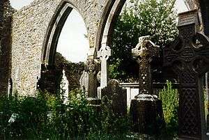
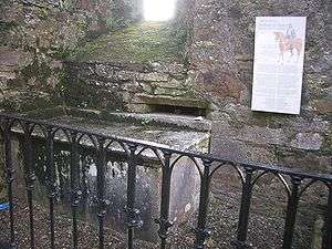
In 1661, the friary was granted to the first lord of Clancarty. It was vested in the Commissioners of Public Works in 1892. However, as late as 1832, a small number of friars remained living on the site. A graveyard is situated within the ruins of the Abbey. This was the burials place of the MacCarthys of Muskerry from 1494 to 1616, commencing with Cormac MacCarthy. No trace of the MacCarthy tombs survive. The Friary has been used for general burial since the early 17th century. Art Ó Laoghaire is buried here.[2]
Features
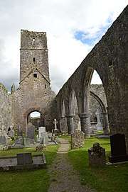
Kilcrea Friary consists of a nave and chancel church with tower, cloister and surrounding east, west and north range of buildings. The nave measures 25.95m in length by 7.20m in width. The friary is carefully laid out on a square and the church is entered through a doorway in its west gable. An arcade separates the nave from the south aisle and transept. A recess for a holy water stoup is found outside the doorway and in the gable over the doorway are the remains of a large, three-light window.
The tower contained four storeys which had timber floors supported on stone corbels. Each storey was lit by plain, narrow, flat-headed windows, except for the top storey where there is a single ogee-headed light in each wall. No trace survives of the high altar which would have been sited under the east window, but an arched piscina is found nearby in the south wall.[2] On the north side of the church is the cloister area and domestic buildings, which include the remains of the chapter room, the refectory and dormitories. Adjoining the chancel of the church is the sacristy, above which is the scriptorium. A 15th-century manuscript written at Kilcrea is preserved in Rennes, France.[5]
Other burials
- Thomas O'Herlahy, Catholic Bishop of Ross (1561–1580)
See also
References
- ↑ O'Neil, 7
- 1 2 3 "Kilcrea Abbey Friary". Kilcrea Abbey Friary website. Retrieved 2008-06-12.
- ↑ Measom, George. "Illustrated Guide Great Southern Western Railway". C. Griffin & Company, 1870. p. 381
- ↑ Noonan (2001), p. 86
- 1 2 "Kilcrea Friary". Ovens Parish. Retrieved 2008-06-12.
- ↑ "Kilcrea Friary". Inchigeelagh.net Community Internet. Archived from the original on July 3, 2008. Retrieved 2008-06-12.
Sources
- O'Neil, Timothy. The Irish Hand: Scribes and Their Manuscripts from the Earliest Times to the Seventeenth Century. Cork: Cork University Press, 2014
- Noonan, Damien. Castles and Ancient Monuments in Ireland. Arum Press, 2001. ISBN 1-8541-0752-6
- Power et al. 1997, Archaeological Inventory of County Cork, Vol. III, 372, No. 9482
External links
Coordinates: 51°51′53″N 8°42′40″W / 51.86472°N 8.71111°W
| Wikimedia Commons has media related to Kilcrea Friary. |