Hotan River
| Hotan River | |
|---|---|
 The Hotan River is formed by the union of the White Jade and Black Jade Rivers in northern China.[1] | |
| Native name | 和田河 |
| Physical characteristics | |
| Main source |
Karakash River, White Jade River 38°05′N 80°34′E / 38.08°N 80.56°E |
| River mouth |
Tarim River 40°28′43″N 80°56′39″E / 40.478479°N 80.944169°ECoordinates: 40°28′43″N 80°56′39″E / 40.478479°N 80.944169°E |
| Basin features | |
| River system | Tarim River |
| Hotan River | |||||||||
| Chinese name | |||||||||
|---|---|---|---|---|---|---|---|---|---|
| Chinese | 和田河 | ||||||||
| |||||||||
| Old name | |||||||||
| Traditional Chinese | 和闐河 | ||||||||
| Simplified Chinese | 和阗河 | ||||||||
| |||||||||
| Uyghur name | |||||||||
| Uyghur |
خوتەن دەرياسى | ||||||||
| |||||||||
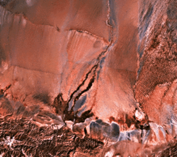
The Hotan River (formerly known as the Khotan River or the Ho-t'ien River) is formed by the union of the White Jade (Yurungkash) and Black Jade (Karakash) Rivers, which flow north from the Kunlun Mountains into the Taklamakan Desert in northern China. The two rivers unite towards the middle of the desert, some 145 kilometres (90 mi) north of the town of Hotan. The river then flows 290 kilometres (180 mi) northwards across the desert and empties itself into the Tarim River.[2] Because the river is fed by melting snow from the mountains, it only carries water during the summer and is dry the rest of the year. Prior to construction of the Tarim Desert Highway in 1995, the Hotan river bed provided the only transportation system across the Tarim Basin.[3]
References
- ↑ http://www.travel-silkroad.com/english/dongfanwenming/history/htsj/gyzkc.htm
- ↑ "Khotan-Darya". 1911 Encyclopædia Britannica.
- ↑ The Southwest Taklimakan Desert from NASA's Geomorphology from Space Archived 2006-09-29 at the Wayback Machine.. Retrieved March 29, 2014.