Qashqadaryo Region
| Qashqadaryo Region Qashqadaryo viloyati | |
|---|---|
| Region | |
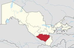 Qashqadaryo in Uzbekistan | |
| Coordinates: 38°50′N 66°50′E / 38.833°N 66.833°ECoordinates: 38°50′N 66°50′E / 38.833°N 66.833°E | |
| Country | Uzbekistan |
| Capital | Qarshi |
| Area | |
| • Total | 28,568 km2 (11,030 sq mi) |
| Elevation | 480 m (1,570 ft) |
| Population (2017) | |
| • Total | 3,088,800 |
| • Density | 110/km2 (280/sq mi) |
| Time zone | UTC+5 (East) |
| • Summer (DST) | UTC+5 (not observed) |
| ISO 3166 code | UZ-QA |
| Districts | 13 |
| Cities | 12 |
| Townships | 4 |
| Villages | 1064 |
| Website |
www |
Qashqadaryo Region (Uzbek: Qashqadaryo viloyati, Қашқадарё вилояти, قەشقەدەريا ۋىلايەتى; old spelling Kashkadarya Region) is one of the regions of Uzbekistan, located in the south-eastern part of the country in the basin of the Qashqadaryo River and on the western slopes of the Pamir-Alay mountains. It borders with Tajikistan, Turkmenistan, Samarqand Region, Bukhara Region and Surxondaryo Region. It covers an area of 28,400 km². The population is estimated to be around 2,067,000 (2007),[1] with some 73% living in rural areas.
Administrative divisions
The regional capital is Karshi (Qarshi) (pop est 177,000 inhabitants). Other major towns include Beshkent, Chirakchi (Chiroqchi), Guzar (G‘uzor), Kitab, Koson, Myrishkor, Muborak, Kamashi (Qamashi), Shahrisabz, Shurbazar, and Yakkabog.

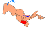
Qashqadaryo Region is currently (As of 2009) divided into thirteen administrative districts.[2]
Latinization of district names is in accordance with the official Uzbekistan governmental website.[2]
Geography
The climate is a typically arid continental climate and partly semi-tropical.
Economy
Natural resources include significant petroleum and natural gas reserves, with the Mubarekh Oil and Gas Processing Plant as the region’s largest industry. Other industry includes wool processing, textiles, light industry, food processing and construction materials. Major agricultural activities include cotton, various crops and livestock. The irrigation infrastructure is very well developed with the large Tollimarjon reservoir as a reliable water source.
The region has a well-developed transport infrastructure, with over 350 km of railways and 4000 km of surfaced roads.
Culture
The city of Shahrisabz, the birthplace of Amir Temur, is the main tourist attraction in the region.
Notes
| Wikimedia Commons has media related to Qashqadaryo Region. |
- ↑ "География Узбекистана" ("Geography Uzbekistan"), Geosite, in Russian, accessed 6 June 2009
- 1 2 "Kashkadarya regional administration (Viloyat)" Archived July 13, 2007, at the Wayback Machine., on the official website of the Uzbekistan government]
Places adjacent to Qashqadaryo Region | ||||||||||
|---|---|---|---|---|---|---|---|---|---|---|
| ||||||||||
Capital: Qarshi | ||
| Districts and seats |
|  |
| ||