Karbala Sports City
 | |
| Full name | Karbala International Stadium |
|---|---|
| Location | Karbala, Iraq |
| Owner | Government of Iraq |
| Capacity | 30,000[2] |
| Surface | Track & Field (Grass) |
| Construction | |
| Built | 2013–2016 |
| Opened | 12 May 2016 |
| Construction cost | $100 Million |
| Services engineer | Bahadır Kul Arcitects (BKA) |
| Main contractors | Bahadır Kul Arcitects (BKA) |
| Tenants | |
| Karbalaa FC | |
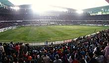
Karbala International Stadium (Arabic: ملعب كربلاء الدولي; ) is the largest sports stadium[3] in the city of Karbala and the middle-Euphrates area. It can accommodate more than 30 thousand spectators and was opened on 12 May 2016.
Description
Karbala International Stadium's construction was started in January 2013 and the construction was at an overall cost of $100,000,000 funded by the government of Iraq. It is a grass surfaced football (soccer) arena with a total area of 34,000m 2. It can seat up to 30,000 spectators and has other sports related facilities. It was designed and built by Bahadır Kul Arcitects.[4] It is owned by the Iraqi national government and is home to Kerbala Football Club (Karbala'a Sport Club).
It opened on 12 May 2016 with a football match between Karbalaa FC and the Iraq's 2007 AFC Asian Cup-winning team in the presence of 30 thousand spectators, including the governor of Karbala and the Iraqi Minister of Youth and Sports, and the game ended 0–0.[5] On 13 November 2017, the first international friendly match was held on the pitch between the Iraqi and Syrian national teams; the match ended in a draw.
List of international matches
- As of 13 November 2017
| No. | Date | Opponent | Score | Competition | Attendance |
|---|---|---|---|---|---|
| 1. | 13 November 2017 | 1–1 | Friendly | 30,000 |
References
- ↑ http://www.meinhardtgroup.com/projects/karbala-olympic-stadium-complex/
- ↑ "Karbala International Stadium – StadiumDB.com". stadiumdb.com.
- ↑ "تعادل إيجابي بين العراق وسوريا في ملعب كربلاء الدولي".
- ↑ Stadyumu, Bahadır Kul, Makroser, Yazılım, Architect, Mimarlık, Konya Stadyumu, Mersin Stadyumu, Kayseri. "BKA | Bahadır KUL Architect". bkaarchitecture.com. Retrieved 2018-03-03.
- ↑ "Report". rudaw.net.
Coordinates: 32°33′54″N 44°00′15″E / 32.565082°N 44.004240°E