Karafuto Prefecture
- Karafuto leads here. For other uses, see Karafuto (disambiguation)
| Karafuto Prefecture 樺太庁 | ||||||
| External territory, later prefecture, of the Empire of Japan | ||||||
| ||||||
| ||||||
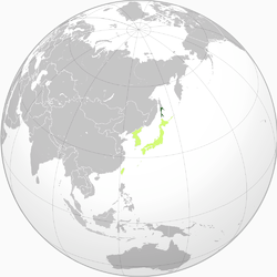 Light green: Other constituents of Imperial Japan | ||||||
| Capital | Toyohara | |||||
| History | ||||||
| • | Japanese invasion | 7–31 July 1905 | ||||
| • | Prefecture status | 1907 | ||||
| • | Upgraded to "inner land" | 1943 | ||||
| • | Soviet invasion | 11–25 August 1945 | ||||
| Population | ||||||
| • | December 1941 | 406,557 | ||||
| Today part of | ||||||
.svg.png)

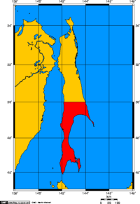
Karafuto Prefecture, commonly called South Sakhalin, was the name of the Japanese territory on southern Sakhalin island from 1905 to 1945.
Through the Treaty of Portsmouth, the portion of the island south of 50°N became a colony of Japan in 1905. In 1907 the prefecture of Karafuto was established, with its capital at Ōtomari (now Korsakov) in 1905 and later Toyohara (now Yuzhno-Sakhalinsk) in 1907. In 1945, with the defeat of Japan in World War II, Karafuto was occupied by Soviet troops and its Japanese administration ceased to function. Karafuto Prefecture was formally abolished as a legal entity on June 1, 1949. Since 1951, the southern part of Sakhalin has been a part of Sakhalin Oblast in the Soviet Union (now Russia).
Name
The Japanese name Karafuto comes from Ainu kamuy kar put ya mosir, which means "the island a god has created on the estuary (of Amur River)". It was formerly known as Kita Ezo, meaning Northern Ezo (Ezo was the former name for Hokkaido). When the Japanese administered the prefecture, Karafuto usually meant Southern Sakhalin only. For convenience, the northern part of the island was sometimes called Sagaren.
In Russian, the entire island was named Sakhalin or Saghalien. It is from Manchu sahaliyan ula angga hada, meaning "peak of the mouth of Amur River". The southern part was simply called Yuzhny Sakhalin ("South Sakhalin"). In Korean, the name is Sahallin or Hwataedo, with the latter name in use during Korea under Japanese rule.
History
Japanese settlement on Sakhalin dates to at least the Edo period. Ōtomari was established in 1679, and cartographers of the Matsumae domain mapped the island, and named it "Kita-Ezo". Japanese cartographer and explorer Mamiya Rinzō established that Sakhalin was an island through his discovery of what is now named Mamiya Strait (Strait of Tartary) in 1809. Japan unilaterally proclaimed sovereignty over the whole island in 1845, but its claims were not recognized by the Russian Empire, fearing that Qing dynasty China might reclaim Vladivostok and Outer Manchuria (known in China as the Sixty-Four Villages East of the River).
The 1855 Treaty of Shimoda acknowledged that both Russia and Japan had joint rights of occupation to Sakhalin, without setting a definite territorial demarcation. As the island became settled in the 1860s and 1870s, this ambiguity led to increasing friction between settlers. Attempts by the Tokugawa shogunate to purchase the entire island from the Russian Empire failed, and the new Meiji government was unable to negotiate a partition of the island into separate territories. In the Treaty of Saint Petersburg (1875), Japan agreed to give up its claims on Sakhalin in exchange for undisputed ownership of the Kuril Islands.
Japan invaded Sakhalin in the final stages of the Russo-Japanese War of 1904–1905, but per the 1905 Treaty of Portsmouth was allowed to retain only the southern portion of the island below the 50° N parallel. Russia retained the northern portion, although the Japanese were awarded favorable commercial rights, including fishing and mineral extraction rights in the north. In 1907, Karafuto Prefecture was officially established, with the capital at Ōtomari. In 1908, the capital was relocated to Toyohara.
In 1920, Karafuto was officially designated an external territory of Japan, and its administration and development came under the aegis of the Ministry of Colonial Affairs. Following the Nikolaevsk Incident in 1920, Japan briefly seized the northern half of Sakhalin, and occupied it until the establishment of formal diplomatic relations with the Soviet Union in 1925; however, Japan continued to maintain petroleum and coal concessions in northern Sakhalin until 1944. In 1943, the status of Karafuto was upgraded to that of an "inner land", making it an integral part of the Empire of Japan.
As Japan was extending its influence over East Asia and the Pacific through the establishment of a Greater East Asia Co-Prosperity Sphere, the Imperial Japanese Army as part of its offensive contingency plans to invade the Soviet Union if it either became involved in the Pacific War or collapsed due to the ongoing German invasion, proposed the annexation of the remaining northern half of Sakhalin to Japan.[1]
Soviet invasion
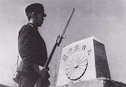
In August 1945, after repudiating the Soviet–Japanese Neutrality Pact, the Soviet Union invaded Karafuto. The Soviet attack started on August 11, 1945, three weeks before the surrender of Japan. The Soviet 56th Rifle Corps, part of the 16th Army, consisting of the 79th Rifle Division, the 2nd Rifle Brigade, the 5th Rifle Brigade and the 214 Armored Brigade,[2] attacked the Japanese 88th Infantry Division. Although the Soviet Red Army outnumbered the Japanese by three to one, they advanced only slowly due to strong Japanese resistance. It was not until the 113th Rifle Brigade and the 365th Independent Naval Infantry Rifle Battalion from Sovetskaya Gavan landed on Tōro, a seashore village of western Karafuto on August 16 that the Soviets broke the Japanese defense line. Japanese resistance grew weaker after this landing. Actual fighting continued until August 21. Between August 22 and August 23, most remaining Japanese units agreed to a ceasefire. The Soviets completed the conquest of Karafuto on August 25, 1945 by occupying the capital of Toyohara.
Post-war
There were over 400,000 people living in Karafuto when the Soviet offensive began in early August 1945. Most were of Japanese or Korean extraction, though there was also a small White Russian community as well as some Ainu indigenous tribes. By the time of the ceasefire approximately 100,000 civilians had managed to escape to Hokkaidō. The military government established by the Soviet Army banned the local press, confiscated cars and radio sets and imposed a curfew. Local managers and bureaucrats were made to aid Russian authorities in the process of reconstruction, before being deported to labor camps, either on North Sakhalin or in Siberia. In schools, courses in Marxism–Leninism were introduced, and Japanese children were obliged to sing songs in praise of Stalin.
Step by step Karafuto lost its Japanese identity. Sakhalin Oblast was created in February 1946, and by March all towns, villages and streets were renamed with Russian names. More and more colonists began to arrive from mainland Russia, with whom the Japanese were obliged to share the limited stock of housing. In October 1946 the Soviets began to repatriate all remaining Japanese. By 1950 most had been sent, willing or not, to Hokkaidō, though they had to leave all of their possessions behind, including any currency they had, Russian or Japanese. Today some keep alive the memory of their former home in the meetings of the Karafuto Renmei, an association for former Karafuto residents.
In 1945, with the defeat of Japan in World War II, the Japanese administration in Karafuto ceased to function. The Japanese government formally abolished Karafuto Prefecture as a legal entity on June 1, 1949. In 1951, at the Treaty of San Francisco, Japan was coerced and renounced its rights to Sakhalin, but did not formally acknowledge Soviet sovereignty over it.[3] Since that time, no final peace treaty has been signed between Japan and Russia, and the status of the neighboring Kuril Islands remains disputed.
(For subsequent history, see Sakhalin Oblast.)
Geography
Economy
The pre-war economy of Karafuto was based on fishing, forestry and agriculture, together with extraction of coal and petroleum. In terms of industry, the paper industry and the charcoal production industry were well developed. Karafuto suffered from a labor shortage through most of its history, and tax incentives were provided to encourage immigration.[4] During World War II, a large number of Koreans were also forcibly relocated to Karafuto.
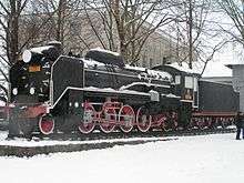
An extensive railway network was constructed in Karafuto to support the extraction of natural resources. The Karafuto Railway Bureau (樺太鉄道局 Karafuto Tetsudōkyoku) maintained 682.6 kilometers of track in four main lines, and an additional 58.2 kilometers of track.
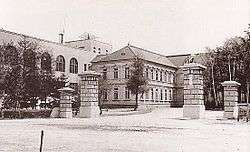
Government
Karafuto was administered from the central government in Tokyo as the Karafuto Agency (樺太庁 Karafuto-chō) under the Colonization Bureau (拓務局 Takumukyoku) of the Home Ministry. The Colonization Bureau became the Ministry of Colonial Affairs (拓務省 Takumushō) in 1923 at which time Karafuto was officially designated an overseas territory of the Empire of Japan.
When the Ministry of Colonial Affairs was absorbed into the new Ministry of Greater East Asia in 1942, the administration of Karafuto was separated, and Karafuto became an integral part of the Japanese archipelago.
Directors of the Karafuto Agency
| Name | From | To |
|---|---|---|
| Kiichirō Kumagai | July 28, 1905 | March 31, 1907 |
| Kusunose Yukihiko | April 1, 1907 | April 24, 1908 |
| Takejirō Tokonami | April 24, 1908 | June 12, 1908 |
| Sadatarō Hiraoka | June 12, 1908 | June 5, 1914 |
| Bunji Okada | June 5, 1914 | October 9, 1916 |
| Akira Masaya | October 13, 1916 | April 17, 1919 |
| Kinjirō Nagai | April 17, 1919 | June 11, 1924 |
| Akira Masaya (second term) | June 11, 1924 | August 5, 1926 |
| Katsuzō Toyota | August 5, 1926 | July 27, 1927 |
| Kōji Kita | July 27, 1927 | July 9, 1929 |
| Shinobu Agata | July 9, 1929 | December 17, 1931 |
| Masao Kishimoto | December 17, 1931 | July 5, 1932 |
| Takeshi Imamura | July 5, 1932 | May 7, 1938 |
| Munei Toshikazu | May 7, 1938 | April 9, 1940 |
| Masayoshi Ogawa | April 9, 1940 | July 1, 1943 |
| Toshio Ōtsu | July 1, 1943 | November 11, 1947 |
Major cities
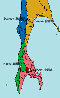
As of 1945, Karafuto was divided into four subprefectures, which in turn were subdivided into 11 districts, in turn divided into 41 municipalities (one city, 13 towns, and 27 villages)
Karafuto's largest city was Toyohara. Other major cities included Esutoru in the north central and Maoka in the south central region.
The list below are the towns and the city of the prefecture. These in italics are the corresponding current Russian names.
Esutoru Subprefecture (恵須取支庁)
- Towns
Maoka Subprefecture (真岡支庁)
- Towns
Shikuka Subprefecture (敷香支庁)
- Towns
Toyohara Subprefecture (豊原支庁)
- City
- Toyohara (豊原市, Yuzhno-Sakhalinsk)
- Towns
See also
Notes
- ↑ Krebs, Gerhard (1997). "31. Japan and the German-Soviet War". In Wegner, Bernd. From peace to war: Germany, Soviet Russia, and the world, 1939–1941. Berghahn Books. p. 551. ISBN 1-57181-882-0.
- ↑ 16th Army, 2nd Far Eastern Front, Soviet Far East Command, 09.08,45
- ↑ Sevela, Marie. "Sakhalin: The Japanese Under Soviet rule". History Today, Vol. 48, 1998.
- ↑ Steven Ivings: Recruitment and coercion in Japan’s far north: Evidence from colonial Karafuto’s forestry and construction industries, 1910–37, in: Labor History, Vol. 57 (2016), No. 2, pp. 215-234.
References
- Sevela, Marie, "Sakhalin: The Japanese under Soviet rule". History and Memory, January 1998, pp. 41–46.
- Sevela, Marie, "Nihon wa Soren ni natta toki. Karafuto kara Saharin e no ikô 1945–1948". Rekishigakukenkû, 1995, no. 676, pp. 26–35, 63.
External links
| Wikimedia Commons has media related to Karafuto. |