Kamieniec Ząbkowicki
| Kamieniec Ząbkowicki | ||
|---|---|---|
| Village | ||
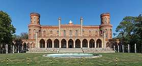 Palatial castle located in the village | ||
| ||
 Kamieniec Ząbkowicki | ||
| Coordinates: 50°31′35″N 16°52′41″E / 50.52639°N 16.87806°E | ||
| Country |
| |
| Voivodeship | Lower Silesian | |
| County | Ząbkowice Śląskie | |
| Gmina | Kamieniec Ząbkowicki | |
| Population | 4,200 | |
| Website | kamienieczab.pl | |
Kamieniec Ząbkowicki [kaˈmjɛɲɛt͡s zɔmpkɔˈvit͡ski] (German: Kamenz N.S.) is a village in Ząbkowice Śląskie County, Lower Silesian Voivodeship, in south-western Poland.[1] It is the seat of the administrative district (gmina) called Gmina Kamieniec Ząbkowicki. Prior to 1945 it was in Germany under the name of Kamenz. Kamieniec Zabkowicki is an important railroad junction, located on the main line Wrocław - Kłodzko - Prague. In Kamieniec, this route crosses with the west-east connection from Jaworzyna Śląska to Kędzierzyn-Koźle.
It lies approximately 8 kilometres (5 mi) south-east of Ząbkowice Śląskie, and 68 kilometres (42 mi) south of the regional capital Wrocław. The village has a population of 4,200.
The place is known for the former Kamieniec Abbey, established in 1209 as an Augustinian college by Bishop Wawrzyniec of Wrocław at the site of a former castle of Bretislaus II of Bohemia. In 1247 it became a filial monastery of the Cistercian Lubiąż Abbey. King Frederick II of Prussia hid here from Habsburg troops on February 27, 1741 during the First Silesian War.
Secularized in 1810 by order of King Frederick William III of Prussia, the estates of Kamenz were acquired by Wilhelmine of Prussia, wife of King William I of the Netherlands. Between 1838 and 1873 their daughter Princess Marianne of the Netherlands and her husband Prince Albert of Prussia had a new palace built in a Neogothic style according to the plans of Karl Friedrich Schinkel.
The Palace was plundered and set on fire by the occupying Soviet Red Army during World War II; it was restored in 1995. After World War II the region was placed under Polish administration by the Potsdam Agreement under territorial changes demanded by the Soviet Union. The village was renamed Kamieniec Ząbkowicki, and most Germans fled or were expelled and replaced with Poles expelled from the Polish areas annexed by the Soviet Union.
Surroundings
- Kamieniec Ząbkowicki Palace
- Gola Dzierżoniowska Castle
- Medieval town of Niemcza
- Cistercian monastery at Henryków
- Wojsławice Arboretum
References
External links
- (in Polish) Kamieniec Palace
| Wikimedia Commons has media related to Kamieniec Ząbkowicki. |
| Seat |  | |
|---|---|---|
| Other villages | ||
Coordinates: 50°31′35″N 16°52′41″E / 50.52639°N 16.87806°E