Cordillera Carabaya
| Carabaya mountain range | |
|---|---|
 | |
| Highest point | |
| Peak | Allin Capac |
| Elevation | 5,780 m (18,960 ft) |
| Dimensions | |
| Length | 75 km (47 mi) N-S |
| Geography | |
| Country | Peru |
| State/Province | Puno |
| Range coordinates | 13°54′32″S 70°24′33″W / 13.908875°S 70.409041°WCoordinates: 13°54′32″S 70°24′33″W / 13.908875°S 70.409041°W |
| Parent range | Andes |
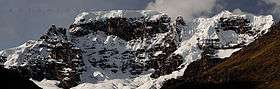
The Cordillera Carabaya (Spanish for "Carabaya mountain range")[1] lies in the Andes of Peru. It extends between 14°00' and 14°22'S and 69°38' and 70°19'W for about 75 km.[2] It is located in the Puno Region, Carabaya Province, between the Vilcanota mountain range in the north-west and the Apolobamba mountain range in the south-east, north and north-east of Macusani.
Mountains
The highest peak in the range is Allincapac at 5,805 metres (19,045 ft). Other mountains are listed below:[3][4][5]
|
|
See also
References
- ↑ Teofilo Laime Ajacopa, Diccionario Bilingüe Iskay simipi yuyayk'ancha, La Paz, 2007 (Quechua-Spanish dictionary): kallawaya. - s. Provincia de Antisuyu. Los habitantes de dicha provincia eran y siguen siendo hábiles herbolarios (JL). || Código idiomático usado por los herbolarios llamados kallawayas.
- ↑ usgs.gov USGS, Peruvian Cordilleras
- ↑ Taken from Mountaineering in the Andes by Jill Neate RGS-IBG Expedition Advisory Centre, 2nd edition, May 1994
- ↑ Michael Cocker, Frost, Dust and Tear Gas, Exploratory Mountaineering in the Peruvian Cordillera Carabaya, in: Alpine Journal 2008, p. 53-69
- ↑ allthemountains.com Maps of the Eastern Andes of Peru including two maps of the Carabaya mountain range (inactive website)
This article is issued from
Wikipedia.
The text is licensed under Creative Commons - Attribution - Sharealike.
Additional terms may apply for the media files.