Kakunodate Station
Kakunodate Station 角館駅 | |
|---|---|
 Kakunodate Station | |
| Location |
68 Obonai Aze Danzaka, Semboku, Akita Japan |
| Operated by | JR East |
| Line(s) | Tazawako Line |
| History | |
| Opened | 30 July 1921 |
| Traffic | |
| Passengers (FY2012) | 688 daily |
| Location | |
 Kakunodate Station Location within Japan | |
Kakunodate Station (角館駅 Kakunodate-eki) is a railway station in Semboku, Akita Prefecture, Japan, operated by East Japan Railway Company (JR East).
Lines
Kakunodate Station is served by the Tazawako Line and the Akita Shinkansen, and is located 58.8 km from the terminus of both lines at Morioka Station. It is also a terminus for the Akita Nairiku Jūkan Railway Akita Nairiku Line
Station layout
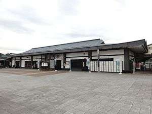
Kakunodate Station consists of a single side platform and an island platform serving the JR portion of the station, and a single side platform for the Akita Nairuke Railway. The station building, designed to resemble a samurai residence, was selected to be one of the Hundred Stations of Tohoku.
Platforms (JR)
| 1 | ■ Tazawako Line | for Morioka |
| 1 | ■ Akita Shinkansen | for Morioka |
| 2 | ■ Tazawako Line | for Akita |
| 2 | ■ Akita Shinkansen | for Akita |
| 3 | ■ Tazawako Line | for bidirectional traffic |
Platforms (Akita Nairiku)
| 1 | ■ Akita Nairiku Line | for Takanosu |
Adjacent stations
| « | Service | » | ||
|---|---|---|---|---|
| Akita Shinkansen | ||||
| Tazawako | - | Ōmagari | ||
| Tazawako Line | ||||
| Rapid: Does not stop at this station | ||||
| Shōden | - | Uguisuno | ||
| Akita Nairiku | ||||
| Terminus | Rapid | Takanosu | ||
| Terminus | - | Ugo-Ōta | ||
History
Kakunodate Station opened on July 30, 1921 as a station on the Obonai Railway, which was nationalized into the Japanese Government Railways (JGR) the following year. The JGR became Japan National Railways (JNR) after World War II. The Kakunodate Line (which later became the Akita Nairiku Railway) began operation from November 1, 1971.. The station was absorbed into the JR East network upon the privatization of the JNR on April 1, 1987. Services on the Akita Shinkansen began on March 22, 1997.
Surrounding area
- Samurai residences (buke yashiki)
- Kakunodate Post Office
External links
| Wikimedia Commons has media related to Kakunodate Station. |
- JR East Station information (in Japanese)
- Akita Nairiku Railway Station information (in Japanese)
Coordinates: 39°35′30.2″N 140°34′15.6″E / 39.591722°N 140.571000°E