Kahlersberg
| Kahlersberg | |
|---|---|
 The Kahlersberg from the north | |
| Highest point | |
| Elevation | 2,350 m above sea level (NN) (7,710 ft) |
| Coordinates | 47°31′53″N 13°01′56″E / 47.53139°N 13.03222°ECoordinates: 47°31′53″N 13°01′56″E / 47.53139°N 13.03222°E |
| Geography | |
| Parent range | Berchtesgaden Alps |
| Climbing | |
| First ascent | in 1854 probably by F. v. Schilcher and G. Helblehen |
| Easiest route | Klettersteig: Alpine Club Route 496 from the west |

The Kahlersberg is a 2,350 metre high mountain in the Northern Limestone Alps (Hagen Mountains) in the Berchtesgaden Alps on the border between Germany (Bavaria) and Austria (Salzburg).
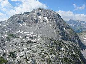
From the west a steep, marked climb (Route 496) runs through the so-called Mausloch ("Mousehole") to the summit. The summit can also be reached along the Eisenpfad ("Iron Path"), a path which approaches from the southwest, from the Landtal valley, is very steep in places and has old markings. A trackless descent variant runs from the Fensterl, a wind gap with a striking, small pit (in the right of the picture; the fourth wind gap left of the summit), northwards and down into the bowl between the Kahlersberg and the Hochseeleinkopf. This descent drops down mainly over steep scree.