Kahale
| Kahale الكحالة Kehale | |
|---|---|
 Kahale Location in Lebanon | |
| Coordinates: 33°49′19″N 35°35′15″E / 33.82194°N 35.58750°ECoordinates: 33°49′19″N 35°35′15″E / 33.82194°N 35.58750°E | |
| Country |
|
| Governorate | Mount Lebanon Governorate |
| District | Aley District |
| Population | |
| • Total | 13,000 |
| Time zone | UTC+2 (EST) |
| • Summer (DST) | +3 |
Kahale (Arabic: الكحالة), is a mountain village in the district of Aley (Caza Aley), Lebanon, 13 km from Beirut. Population estimated at 13,000 residents, all of whom are Maronite Catholic.
Etymology
Kahale is derived from Syriac and Aramaic, from kah (verb meaning breathed or respired); al or el (the name of the Caananite god El, who was considered the father of God and of mankind); and e (an ending denoting that the god El is the speaker's god)
Geography
Considering the locale and geography of the Kahale this name is suited well. A valley extends from the Sh'har west side of the Kahale into the Rjoum, eastern side of the Kahale. In this valley, the winds accelerate as if being sped along by some external supernatural will, the will of the ancient god El.
Religion
Kahale has a predominantly, if not wholly, Maronite Catholic population.
The village has three churches:
- Mar Elias (مار الياس )
- Our Lady (السيدة)
- Mar Antonios (مار انطونيوس)
This in addition to Don Bosco monastery and school, and Saint Charbel Home for the elderly which is now closed.
Geography
Latitude: 33°49'18.64"N, longitude: 35°35'14.55"E, 200 to 500 m above sea level and a land size of approximately 1.96 square kilometers.
External links
References
- Abi Khalil, Charbel. (1997). History of the Kahale. Beirut: The Arabic Press.
Capital: Aley | ||
| Towns and villages | 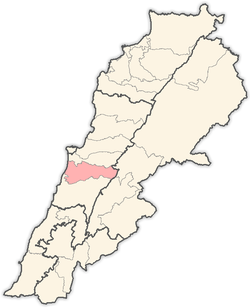 | |