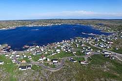
Joe Batt's Arm, Fogo Island
| Joe Batt's Arm | |
|---|---|
| Community | |
 | |
| Coordinates: 49°43′21″N 54°08′57″W / 49.72250°N 54.14917°W | |
| Country |
|
| Province |
|
| Population (2006) | |
| • Total | 778 |
| Time zone | UTC-3:30 (Newfoundland Time) |
| • Summer (DST) | UTC-2:30 (Newfoundland Daylight) |
| Area code(s) | 709 |
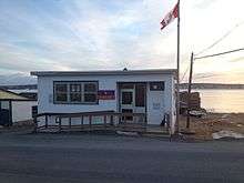
Post office in Joe Batts Arm, Fogo Island, NL, Canada
Joe Batt's Arm is a community in the Canadian province of Newfoundland and Labrador, located on Fogo Island. It was previously incorporated as a town prior to becoming part of the Town of Fogo Island through an amalgamation in 2011.[1] The former town had a population of 778 in the Canada 2006 Census. This makes it the largest community on the island. [1]
See also
External links
References
Coordinates: 49°43′21″N 54°08′57″W / 49.72250°N 54.14917°W
This article is issued from
Wikipedia.
The text is licensed under Creative Commons - Attribution - Sharealike.
Additional terms may apply for the media files.