Ichocollo (Tacna)
| Ichocollo | |
|---|---|
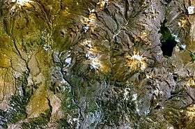 The lake named Vilacota (on the right) and Ichocollo southwest of it as seen from above (NASA Landsat7 image) | |
| Highest point | |
| Elevation | 4,400 m (14,400 ft) [1] |
| Coordinates | 17°14′14″S 70°06′54″W / 17.23722°S 70.11500°WCoordinates: 17°14′14″S 70°06′54″W / 17.23722°S 70.11500°W |
| Geography | |
 Ichocollo Peru | |
| Location | Peru, Tacna Region, Candarave Province, Tarata Province |
| Parent range | Andes |
Ichocollo (possibly from Aymara jichu ichu, Peruvian feather grass, qullu mountain,[2] "ichu mountain") is a mountain in the Andes of southern Peru which reaches a height of approximately 4,400 m (14,400 ft). It is located in the Tacna Region, Candarave Province, Candarave District, and in the Tarata Province, Susapaya District. Ichocollo lies southwest of Chillihua.[1]
References
- 1 2 escale.minedu.gob.pe - UGEL map of the Tarata Province (Tacna Region)
- ↑ Radio San Gabriel, "Instituto Radiofonico de Promoción Aymara" (IRPA) 1993, Republicado por Instituto de las Lenguas y Literaturas Andinas-Amazónicas (ILLLA-A) 2011, Transcripción del Vocabulario de la Lengua Aymara, P. Ludovico Bertonio 1612 (Spanish-Aymara-Aymara-Spanish dictionary)
This article is issued from
Wikipedia.
The text is licensed under Creative Commons - Attribution - Sharealike.
Additional terms may apply for the media files.