Jezreel (city)
| Yizri'el | |
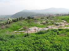 Tel Jezreel looking east toward Gilboa. | |
 Shown within Israel | |
| Location | Yizre'el, Israel |
|---|---|
| Region | Jezreel Valley |
| Coordinates | 32°33′28.27″N 35°19′40.63″E / 32.5578528°N 35.3279528°E |
| Type | palace |
| Part of | town |
| History | |
| Builder | Tribe of Issachar, Ahab |
| Material | stone |
| Cultures | Hebrew, Kingdom of Israel |
| Associated with | Ahab, Jezebel, Naboth, Ahinoam, Jehu, Elijah |
| Site notes | |
| Excavation dates | 1990-1996 |
| Archaeologists | David Ussishkin, John Woodhead |
Jezreel (Hebrew: יִזְרְעֶאל Yizre'el, "God will sow") was an ancient Israelite city and fortress originally within the boundaries of the Tribe of Issachar,[1] and later within the northern Kingdom of Israel. Prior to the division of the United Kingdom of Israel, the city was the hometown of Ahinoam, third wife of King David, Michal, Saul's daughter being the first and Abigail, widow of Nabal being his second.[2] According to the First Book of Kings, the royal palace of King Ahab, "one of the most famous of the royal residences of the kings of Israel",[3] was in Jezreel, adjacent to the vineyard of Naboth.[4] Ahab's capital remained in Samaria.[5]
The modern archaeological site is located on a low hill on the southern edge of the Jezreel Valley's eastern edge in northern Israel.[6] Archaeologists David Ussishkin and John Woodhead believe that Jezreel was a fortress that served as a cavalry base for King Ahab.[6]
Biblical references
According to 1 Kings 18:45-46, following the prophet Elijah's victory over the prophets of Ba'al at Mount Carmel, Elijah instructs Ahab to return home to Jezreel, where he would be reporting on events to Jezebel, his wife, but "the hand of the Lord was upon Elijah" and he reached Jezreel ahead of Ahab.[7] Jezreel is around 50km from Mount Carmel.[8]
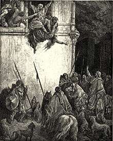
As recounted in 2 Kings 9:1-37, after Jehu kills King Jehoram, he confronts Jezebel in Jezreel and urges her eunuchs to kill Jezebel by throwing her out of a window. They comply, tossing her out the window and leaving her in the street to be eaten by dogs. Only Jezebel's skull, feet, and hands remained.
In 2 Kings 10:8 Jehu orders the death of 70 descendants of Ahab, and has their heads sent to the new king in Jezreel and piled up in "two heaps at the gate entrance."[6]
History
The "breathtaking views" that the site commands to the north and east are considered to have been of strategic importance in Israelite times because the commercial and military highway from Egypt to Syria and Mesopotamia passed through Megiddo, Beth Shean and along the Jezreel Valley.[6] Water was supplied by cisterns inside the walls and by the spring of 'En Jezreel northeast of the fortress.[6] Because of the strategic location, ample water supply, and excellent grazing in the Jezreel Valley, archaeologists David Ussishkin and John Woodhead believe that Jezreel was the base for King Ahab's chariot corps and cavalry.[6]
Jezreel was a 9th-century BCE fortress possibly built during the reign of King Omri but certainly active in the reigns of King Ahab and his consort Queen Jezebel and their son King Jehoram.[6] It was destroyed soon afterward, possibly by the Arameans in the late 9th-century.[6][9] The pottery found in the fortress during the dig all dates to this brief period.[6]
The fortress was built on the site of a small village that existed in the Early Bronze Age (c. 2750-2300 BCE) and Late Bronze Age (c. 1550-1150 BCE).[6]
The fourth-century Christian nun and pilgrim Egeria visited Jezreel and reported that "the tomb of Jezebel is stoned by everyone to this very day."[6]
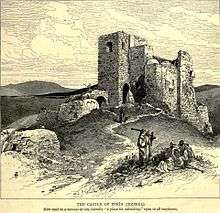
Jezreel was the site of a Byzantine-era village, a Crusader-period village belonging to the Knights Templar, and an Arab period village named Zir'in (derived from the ancient name Jezreel).[6] A "beautiful Crusader church still stands largely intact.[6] Benjamin of Tudela visited Jezreel in 1165 CE and reports that a Jewish man "a dyer by profession" lived there.[10] It was the site of a large Ottoman-era fortified tower.[6] During the Israeli War of Independence the village of Ze'rin "became a central base for Arab forces" and was therefore conquered and the site cleared.[6]
Archaeology
Archaeologists David Ussishkin and John Woodhead led a dig at Jezreel.[6] In 1987, a bulldozer working near the site accidentally uncovered ancient structures, and a salvage dig was conducted, leading to the major dig under the direction of Ussishkin and Woodhead over seven seasons from 1990-1996.[6] Staff and volunteers from about 25 countries (the largest groups were from United Kingdom, Sweden and Denmark) joined the dig.
Renewed excavations began in the summer of 2012 under the new directorship of Dr. Norma Franklin of the University of Haifa Zinman Institute of Archaeology, and Dr. Jennie Ebeling of the University of Evansville.[11] The excavations uncovered a casemate wall and four projecting towers surrounding the fortress, built with a combination of well-cut ashlars, boulders and smaller stones, and an upper level of mud-brick. The fortress enclosed an area of almost 11 acres (45,000 m2). It was 860' long and 470' wide, and defended by a steep slope to the north and a moat 20' deep and rampart on the other three sides.[6]
Pursuant to evidence from this most recent excavation, Dr. Franklin further asserts that Jezreel likely contained both a vineyard and a winery near an installation made to house any visiting Israelite king, which is all consistent with several claims regarding the story of the vineyard's alleged owner—a man named Naboth—made in the Biblical Book of 1 Kings.[12] While vineyards do not leave direct archaeological remains, an independently-conducted soil analysis found a plot of land in Jezreel properly suited for growing grapes, while the soils in the fields further west from the location were found to be the right quality for growing olives.[12] Furthermore, numerous indicators of an ancient winery were discovered at a "particularly impressive installation...carved into the limestone bedrock at the foot of the hill of Jezreel", such indicators including rock-cut treading floors; two adjacent rock-cut vats, each more than one meter in depth; another treading floor connected to a vat by a rock-cut channel; a deep circular basin that possibly functioned as additional vat; and a sump for collecting liquids.[12]
References
- ↑ Joshua 19:18
- ↑ 1 Samuel 25:43
- ↑ Cambridge Bible for Schools and Colleges on 1 Kings 18, accessed 2 November 2017
- ↑ 1 Kings 21:1
- ↑ Pulpit Commentary on 1 Kings 18, accessed 2 November 2017
- 1 2 3 4 5 6 7 8 9 10 11 12 13 14 15 16 17 18 David Ussishkin, "Jezreel—Where Jezebel Was Thrown to the Dogs", Biblical Archaeology Review July / August 2010. Read Online
- ↑ 1 Kings 18:45-46
- ↑ Google Maps, based on modern roads linking Mount Carmel with Yizre'el kibbutz
- ↑ Nadav Na'aman, "Historical and Literary Notes on the Excavation of Tel Jezreel," Tel Aviv 24, 1987, pp. 122-128.
- ↑ Asher, Adolf, The Itinerary of Rabbi Benjamin of Tudela, Hakesheath, New York, 1840, p. 80.
- ↑ Biblical Archaeology Review, May/June 2013
- 1 2 3 Franklin, Norma. "The Story of Naboth's Vineyard and the Ancient Winery in Jezreel". TheTorah.com. Projects TABS (Torah and Biblical Scholarship). Retrieved 29 December 2017.