Japanese General Government Building, Seoul
| Japanese General Government Building, Seoul | |
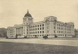 The building in 1929 | |
| Korean name | |
|---|---|
| Hangul | 조선총독부 청사 |
| Hanja | 朝鮮總督府廳舍 |
| Revised Romanization | Joseon-chongdokbu Cheongsa |
| McCune–Reischauer | Chosŏn-ch'ongdokpu Ch'ŏngsa |
| Alternative name | |
| Hangul | 조선총독부 건물 |
| Hanja | 朝鮮總督府建物 |
| Revised Romanization | Joseon-chongdokbu Geonmul |
| McCune–Reischauer | Chosŏn-ch'ongdokpu Kŏnmul |
The Government-General Building, also known internationally as the "Seoul Capitol", was the chief administrative building in Keijo (English: Seoul) during Japanese rule in Korea and the seat of the Governor-General of Korea from 1926 until 1945. The construction of the Governor General's Office began of Korea by Japan in 1926, As headquarters of the Japanese colonial government in Korea, the building was the largest of its kind in east Asia, surpassing even the British in India and the Dutch in Java. After independence the neoclassical building was the scene of numerous important events for the South Korean government, housing first the South Korean National Assembly, and later the National Museum of South Korea. As it was long felt to be a symbol of Japanese imperialism, and it impeded reconstruction of the Gyeongbokgung complex landmarks, it was demolished during 1995 to 1996.
History
After the Korean Empire lost its sovereignty to Japan in 1910, Keijo (English: Seoul) was made the colonial capital of Colonial Korea. It was decided in 1911 to erect a building in Seoul to house the new colonial administration — the Government-General Building.
Location
The Government-General Building was deliberately constructed inside the grounds of the Gyeongbokgung Palace, the former Korean imperial palace, to obstruct the view of Gyeongbokgung from central Seoul and to legimitize Japanese colonial occupation and rule, and all but 10 of the 400 palace buildings were demolished; further demolitions were prevented only by a campaign by Japanese intellectual Muneyoshi Yanagi.
Architecture
The Neoclassical style Government-General Building was designed by German architect Georg De Lalande, and was completed in October 1, 1926. The new structure was a grey granite building with a copperplate dome. Architect De Lalande, who had lived in Japan since 1901 and had designed numerous administrative buildings there, died in 1914 and was succeeded on the project by Japanese architect Nomura Ichiro. Construction began on June 25, 1916 and the structure was officially opened ten years later.
The name of the General Government Building was changed to ‘Capitol Hall’ when the US occupation forces replaced the Colonial Government after Japan’s surrender in 1945. The Capitol Hall later become the Korea's Constitutional Assembly on May 31, 1948. Since the founding of the Republic of Korea, on August 15, 1948, Government Offices have occupied the building. The inauguration of the first President of the South Korea, Syngman Rhee, was held in front of the Capitol Hall and ex-Japanese Governor General's office became the Prime Minister's office.
During the Korean War, the building was briefly occupied by the army of North Korea, and the set fire when the United Nations forces recaptured Seoul in September, 1950. The Building was left unused and in a ruinous state even after the war, because the nationalistic President Rhee refused either to repair the building or reoccupy it. Its ruinous state was partly symbolic of the end of the Japanese occupation.
In 1950s, President Rhee started using the remaining outdoor space as an outdoor music hall. The Capitol Hall was survived to enjoy two more decades as the seat of government, following Park Chung Hee's 1961 military coup. On 22 November, 1962, General Park carried out extensive repair and refurbishing work on the Capitol Hall to use it as the much-needed offices for the central government. As a witness to the major political and social upheavals of modern Korean history, the building housed government offices including that of the Prime Minister, until early 1980s when new quarters were constructed nearby.
On 25 May, 1981, President Chun Doo-hwan gave instruction to move the National Museum of Korea to the Capitol Hall. In 1982, the South Korean Government announced a moving plan to the people of Korea, and the project begun. After the last State Council meeting was held there on 19 May, 1983, it underwent a period of refurbishment, reopening in 1986 as the National Museum of Korea.
Demolition
The issue of the building's future was opened after Kim Young-sam became president in 1993. In August of that year, he announced that it would be demolished, beginning in 1995, the 50th anniversary of the end of the Second World War and Japanese colonial rule, as well as the 600th anniversary of Gyeongbokgung. Plans were announced for a new National Museum.
There was intense public debate on the issue, with Kim and other demolition proponents arguing that the building was a symbol of Japanese imperialism that had been built deliberately to deface Gyeongbokgung Palace. Opponents countered that South Korea, now a wealthy nation, was no longer troubled by such symbolism and that reminders of the colonial era were needed. Many opposed the move on the grounds of the expense incurred and the architectural merit of the existing building (other colonial-era buildings, such as the old Seoul Station and Seoul City Hall, are considered landmarks of the city). The building itself was the site of the declaration of independence of the Republic of Korea.
A proposal was made to move the building to a new site, although this would have been far more expensive than demolition. Nevertheless, demolition began on South Korea's Liberation Day (Gwangbokjeol), August 15, 1995, with the removal of the dome. By late 1996, the building was completely removed.
Legacy
Today, the top of the dome and several other recognizable pieces of the building can be seen at the Independence Hall Museum in Cheonan, as part of a monument to commemorate the history behind the building and its demolition.
Gallery
 President Syngman Rhee is sworn-in at a ceremony in front of the former colonial headquarters on July 24, 1948.
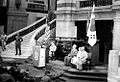 The building is used to host a ceremony on September 29, 1950, to mark the recapture of Seoul by U.N forces in the Korean War.
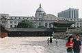 General Government building among the Gyeongbok Palace in 1995.
 By the early 1990s mounting pressure to remove the building from central Seoul gathered momentum.
 The colonial building is demolished behind a decorative screen in 1996.
See also
- Gyeongbokgung Palace complex — constructed in 1394, first reconstructed in 1867, under reconstruction 1989 to present
- Presidential Office Building, Taipei
- Japanese architecture
Notes
| Wikimedia Commons has media related to Japanese General Government Building in Korea. |
Coordinates: 37°34′39″N 126°58′38″E / 37.577393°N 126.97725°E