James Island (La Push, Washington)
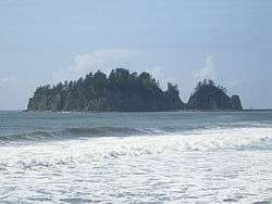


James Island (Quileute: A-ka-lat - "Top of the Rock") is an island at the mouth of the Quillayute River near La Push, Washington, reportedly named for Francis Wilcox James, a lighthouse keeper and friend of the Quileute Indians there,[1] though the Origin of Washington Geographic Names attributes the naming to a Quileute chief named Jimmie Howeshatta.[2][3]
Until the second half of the 19th century, the island was the site of a fortified village. After this, it was used as a site for growing crops for residents of the mainland, as well as a burial site for tribal chiefs. At 160 feet (49 m) in height, the island was also used as a lookout for spotting whales. The island was formerly a sea stack, connected to the mainland, until the US Army Corps of Engineers rerouted the Quillayute River, separating it. Today, the US Coast Guard operates a lighthouse and foghorn for boats coming into the harbor.
In 1966, James Island was removed from the Quillayute Needles National Wildlife Refuge by the U.S. Department of the Interior. The Interior Department returned the island to the Quileute people when it was discovered to be part of the Quileute Indian Reservation.[4] No people outside of the Quileute tribe are allowed on the island.
References
- ↑ "A survey of Port Townsend's Ghost Signs & Murals" (PDF). Jefferson County Historical Society. Retrieved 14 July 2018.
Francis Wilcox James, a native of England, arrived in Port Townsend in 1853. In 1855 he went to La Push as an Indian Agent and Assistant Lighthouse Keeper at Cape Flattery. While at La Push he became wellliked by the Quileute Indians and, as an honoring gesture, they named James Island after him.
- ↑ Meany, Edmond S. (1923). Origin of Washington Geographic Names. University of Washington Press. p. 122. Retrieved 14 July 2018.
JAMES ISLAND, a small island a little south of the mouth of the Quillayute River, in the southwestern part of Clallam County. It was named in honor of Chief Jimmy of the Quillayute Indians. (Fannie Taylor, Mora, in Names MSS., Letter 807.)
- ↑ Majors, Harry M. (1975). Exploring Washington. Van Winkle Publishing Co. p. 64. ISBN 978-0-918664-00-6.
- ↑ Removed by Public Land Order 4095, September 19, 1966, according to Comprehensive Conservation Plan/Environmental Assessment, Chapter 1, page 1-8.
Coordinates: 47°54′20.72″N 124°38′52.04″W / 47.9057556°N 124.6477889°W