Old Jaffa
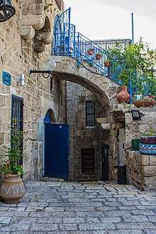
The Old City of Jaffa (Hebrew: יפו העתיקה – Ancient Yafo; Arabic: يافا العتيقه – Ancient Jaffa or يافا القديمة – Old Jaffa) is the historical part of the Israeli city of Jaffa. A neighborhood with art galleries, restaurants, theaters, museums, and nightclubs, it is one of Tel Aviv's main tourist attractions. Jaffa is the southwest district of the Tel Aviv–Jaffa municipality.[1] Old Jaffa is located in the northwest of Jaffa, on a hill along the Mediterranean Sea. Technically the hill of Old Jaffa is the continental north end of a kurkar ridge, further alleviated through fortifications with layers of rubble inside.
History
The Old City was the centre of Jaffa for most of its history. Much of Jaffa was rebuilt during British control after the repeated damage inflicted by the Napoleonic wars and an earthquake in 1837.[2] When the wall of Jaffa was dismantled between 1878 and 1888 to allow expansion, both the city and the centres of government shifted eastwards, though the Old City remained the cultural centre of the city.[3][4][5]
During the Great Revolt in 1936–1939, the connection between Tel Aviv and the Jaffa port was partially severed by disruption in the Old City.[6] This had two primary effects: the British retaliated using massive gelignite charges to destroy at least 220 buildings to leave over 6000 Arabs homeless in retribution[6] and encouraged the building of a small port on the Yarkon estuary to the North of Tel Aviv to reduce reliance on Jaffa.
Disputes about the merging of Tel Aviv and Jaffa, with the former wanting only to add the Jewish neighborhoods in the North of Jaffa and the latter wanting a total merge led to a gradual unification.[7] The Old City was partly added on 18 May 1949 as part of the first Arab-controlled land to fall under Jewish control.[7] The remainder of the Old City would be added in 24 April 1950 when the complete unification occurred.[7]
Old Jaffa has increasingly gentrified with the residential population dropping dramatically and an increasing number of art galleries, restaurants, souvenir shops as well as various ongoing archaeological digs.[8][2] There is a particular interest on the cultural melange by the relatively rare, in Israel, triple mix of Muslims, Jews and Christians.[8] There have been a few accusations that the gentrification and museums towards its history have white-washed Israeli actions in the area, removed Palestinian history and muted reference to British atrocities in the area.[9]
Attractions
- Subregions: Jaffa Port, Yefet Street^
- Museums and galleries: Farkash Gallery, Ilana Goor Museum
- Places of worship: Al-Bahr Mosque, Mahmoudiya Mosque, Saint Nicholas Monastery, St. Peter's Church
- Theaters: Arab-Hebrew Theater, Hasimta Theater, Nalaga'at
- Towers: Jaffa Clock Tower, Jaffa Light
Immediately opposite Old Jaffa: Abouelafia Bakery, Abu Hassan Restaurant
^Forms the eastern border of Old Jaffa and continues south along Ajami, Jaffa.
References
- ↑ inisrael.com, ByTech Ltd. -. "Old Jaffa Tel Aviv travel guide". www.inisrael.com. Retrieved 28 May 2018.
- 1 2 Robert Barzelay (24 January 2017). "Exploring Jaffa: Israel's Ancient Port City". Culture Trip. Retrieved 3 August 2018.
- ↑ Kedar, B.Z. (1999). The Changing Land: Between the Jordan and the Sea: Aerial Photographs from 1917 to the Present. Wayne State University Press. p. 96. ISBN 978-0-8143-2915-3. Retrieved 4 August 2018.
- ↑ Pinsker, S.M. (2018). A Rich Brew: How Cafés Created Modern Jewish Culture. NYU Press. p. 249. ISBN 978-1-4798-2789-3. Retrieved 4 August 2018.
- ↑ LeVine, M. (2005). Overthrowing Geography: Jaffa, Tel Aviv, and the Struggle for Palestine, 1880–1948. University of California Press. p. 56. ISBN 978-0-520-24371-2. Retrieved 4 August 2018.
- 1 2 Hughes, M. (2009) The Banality of Brutality: British Armed Forces and the Repression of the Arab Revolt in Palestine, 1936–39, English Historical Review Vol. CXXIV No. 507, pp. 314–354.
- 1 2 3 Arnon Golan (1995), The demarcation of Tel Aviv-Jaffa's municipal boundaries, Planning Perspectives, vol. 10, pp. 383–398.
- 1 2 Rebecca Amir (13 May 2018). "The art awakening transforming Jaffa". Israel21C. Retrieved 3 August 2018.
- ↑ Léopold Lambert (7 August 2017). "PALESTINE REPORT PART 5: THE COLONIAL AND GENTRIFYING VIOLENCE OF ARCHITECTURE IN JAFFA". FUNAMBULIST. Retrieved 3 August 2018.
Coordinates: 32°3′16.13″N 34°45′10.94″E / 32.0544806°N 34.7530389°E
| Northwest |  | |
|---|---|---|
| Northeast |
| |
| Central |
| |
| Southwest |
| |
| South |
| |
| Southeast |
| |