JA volcano
| JA Volcano | |
|---|---|
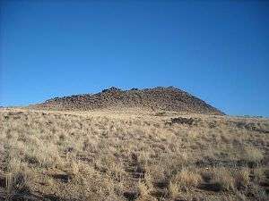 JA Volcano in Petroglyph National Monument, as seen from its western flank on January 14, 2009 | |
| Highest point | |
| Elevation | 5,944 ft (1,812 m) |
| Prominence | 114 ft (35 m) |
| Coordinates | 35°07′39″N 106°46′22″W / 35.1275°N 106.7728°WCoordinates: 35°07′39″N 106°46′22″W / 35.1275°N 106.7728°W |
| Geography | |
| Location | Petroglyph National Monument, Bernalillo County, New Mexico, US |
| Geology | |
| Age of rock | > 10,000 years |
| Mountain type | Stratovolcano |
| Last eruption | 150,000+ years ago |
JA Volcano is an inactive volcano located near Albuquerque, New Mexico. JA Volcano is the southernmost of 5 volcanoes in a 5-mile chain within the western boundary of Petroglyph National Monument. Students from John Adams Middle School in Albuquerque constructed a rock JA image on the East side of the cone which they whitewashed annually. The J is still visible from the city. Directly north of JA is Black, followed by Vulcan, Bond and Butte volcanoes.
The date of its last eruption is unknown, but is believed to have been more than 150,000 years ago.
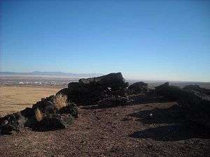
JA Volcano, roughly 2/3 of the way up its north-to-south trail leading to the summit. Albuquerque can be seen in the distance in this view facing east/southeast
http://www.canyoncountryzephyr.com/wp-content/uploads/2014/11/LA10.jpg
| Wikimedia Commons has media related to JA Volcano. |
This article is issued from
Wikipedia.
The text is licensed under Creative Commons - Attribution - Sharealike.
Additional terms may apply for the media files.