Isla Palomino
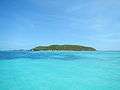 View of Isla Palomino from the coast of Fajardo | |
| Geography | |
|---|---|
| Location | Caribbean Sea |
| Coordinates | 18°20′55″N 65°34′05″W / 18.34861°N 65.56806°W |
| Archipelago | Puerto Rico Archipielago |
| Area | 0.41 km2 (0.16 sq mi) |
| Highest elevation | 50 m (160 ft) |
| Administration | |
|
United States | |
| Territory | Puerto Rico |
| Municipality | Fajardo |
| Demographics | |
| Population | 0 |
| Pop. density | 0 /km2 (0 /sq mi) |
Isla Palomino is a small, uninhabited island located to the east of Puerto Rico, near the coast of Las Croabas, Fajardo.
Geography
Isla Palomino is 0.7 mi (1.1 km) long and maximally 1,722 feet (525 m) wide, measures 102 acres (41 ha) in area and reaches a height of 165 feet (50 m). Coral reefs, seagrass beds, and rocky coast species are among the natural attractions found in Isla Palomino and tiny Isla Palominito, the latter being located about 2,000 feet (600 meters) south of Palomino Island.
Economy
Isla Palomino is the largest of three private islands near Puerto Rico, the other two being Isla de Ramos and Isla de Lobos. The island is owned by the descendants of Alberto Bachman Glauser, the Fuertes Family. Most of the island is rented to El Conquistador Resort for their beach and water activities. A ferry is used to get guests to the island.[1]
Gallery
- Isla Palomino as seen from Isla Palominito
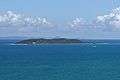 Isla Palomino seen from East, the coast of Fajardo in the background
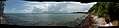 View from the West Beach of Palomino
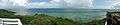 View from the top of Palomino
References
- ↑ "Puerto Rico Water Taxi". Retrieved December 25, 2015.
Coordinates: 18°20′55″N 65°34′05″W / 18.34861°N 65.56806°W