Iremel
| Mount Iremel | |
|---|---|
 | |
| Highest point | |
| Elevation | 1,589 m (5,213 ft) |
| Coordinates | 54°30′54″N 58°50′24″E / 54.51500°N 58.84000°E |
| Geography | |
| Location | Republic of Bashkortostan, Russia |
| Parent range | Ural Mountains |
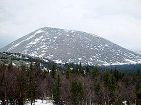
Iremel (Bashkir: Ирәмәл, Russian: Иремель) is a compact mountain ridge in the Southern Ural Mountains in the republic of Bashkortostan, Russian Federation (bordering with Chelyabinsk Oblast to the north-west). The highest peak, Bolshoy Iremel (Big Iremel), or simply Iremel, stands at 1589 metres (5200 ft) high. Maly Iremel (Small Iremel), 6 kilometers north-east, stands at 1449 meters. It is the source of the River Belaya.
The highest peak of the South Urals, Mount Yamantaw (1638 meters) is located 53 kilometers south-west from Bolshoy Iremel.
Gallery

Coordinates: 54°30′54″N 58°50′24″E / 54.51500°N 58.84000°E
This article is issued from
Wikipedia.
The text is licensed under Creative Commons - Attribution - Sharealike.
Additional terms may apply for the media files.