Inishcaltra
| Inishcaltra Inis Cealtra | |
|---|---|
| Civil parish | |
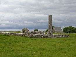 St. Brigid's church and St. Caimin's church and tower on Holy Island | |
 Inishcaltra Location in Ireland | |
| Coordinates: 52°55′53″N 8°25′47″W / 52.931517°N 8.429739°WCoordinates: 52°55′53″N 8°25′47″W / 52.931517°N 8.429739°W | |
| Country | Ireland |
| Province | Munster |
| County | County Clare |
| Time zone | UTC+0 (WET) |
| • Summer (DST) | UTC-1 (IST (WEST)) |
Inishcaltra (Irish: Inis Cealtra[1]) is a civil parish in County Clare. It includes the village of Mountshannon and the island of Inis Cealtra, long the site of religious activities. It forms part of the Catholic parish of Mountshannon (Clonrush).
Location
Inishcaltra is 3.75 miles (6.04 km) northeast of Scarriff. The parish is 4 by 4 miles (6.4 by 6.4 km), and covers 11,283 acres (4,566 ha). It mostly lies on the west shore of Lough Derg, and includes some islands in that lake including Red Island, Inniscalthra, Young's Island, Basley Island, and Cribby Island. There is a belt of low land along the lake, rising into the Slieve-Baughta mountains.[2] The parish includes the village of Mountshannon. The road from Scarriff towards Portumna and Loughrea runs along the lake shore.[2]
History
The island of Inis Cealtra after which the parish is named lies about 0.5 miles (0.80 km) from the shore. It is often called the Holy Island. It was the scene of pre-Christian religious activities. The 70 feet (21 m) pillar tower may have been used in sun worship. More recently the island was the site of Christian structures, including various cells or oratories, now ruined. The main church is the Teampol Camin, named after the founder or patron, Saint Camin who died around 658. The Danish invaded the island in 834, 908 and 946.[2]
The parish was in County Galway from 1610 to 1898.[3] The total population in 1841 was 2,378 in 383 houses.[2] By 1851, after the famine, the number had dropped to 1,457 through emigration and deaths from starvation.[3] In 1898 the parishes of Inishcaltra and Clonrush were transferred from County Galway to County Clare.[4] Today the civil parish is part of the Catholic parish of Mountshannon (Clonrush) in the Roman Catholic Diocese of Killaloe. The church of St Caimin is in Mountshannon.[5]
Townlands
Townlands are Bohateh North, Bohateh South, Cappaduff, Cloonamirran, Cloontyconnaught, Cloontymweenagh, Coogypark, Cooldorragha, Curratober, Derroran East, Derroran West, Derrycon Lower, Derrycon Upper, Dooros, Glenwanish, Inishcaltra, Kilrateera Lower, Kilrateera Upper, Knockaphort, Magherareagh, Middleline North, Middleline South, Mountshannon, Sellernaun East, Sellernaun West and Woodpark.[6]
References
Citations
Sources
- "Inis Cealtra". Placenames Database of Ireland. Retrieved 2014-04-11.
- Madden, Gerard (1993). "For God or King-The History of Mountshannon, County Clare". East Clare Heritage. Retrieved 2014-04-05.
- "Map of Inishcaltra Parish showing Townlands". Clare County Library. Retrieved 2014-04-05.
- "Mountshannon (Clonrush)". Diocese of Killaloe. Retrieved 2014-04-05.
- "Mountshannon Historical Background". Clare County Library. Retrieved 2014-04-05.
- "Inishcaltra". Parliamentary Gazetteer of Ireland 1845. Retrieved 2014-04-05.