Independencia Municipality, Yaracuy
| Independencia Municipality Municipio Independencia | |||
|---|---|---|---|
| Municipality | |||
| |||
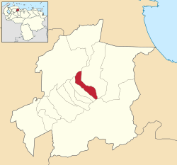 Location in Yaracuy | |||
.svg.png) Independencia Municipality Location in Venezuela | |||
| Coordinates: 10°19′47″N 68°45′10″W / 10.3297°N 68.7528°WCoordinates: 10°19′47″N 68°45′10″W / 10.3297°N 68.7528°W | |||
| Country |
| ||
| State | Yaracuy | ||
| Area | |||
| • Total | 98 km2 (38 sq mi) | ||
| Population (2011) | |||
| • Total | 57,811 | ||
| • Density | 590/km2 (1,500/sq mi) | ||
| Time zone | UTC−04:00 (VET) | ||
| Website | Official website | ||

Independencia is one of the 14 municipalities of the state of Yaracuy, Venezuela. The municipality is located in central Yaracuy, occupying an area of 98 km ² with a population of 57,811 inhabitants in 2011. The capital lies at Independencia.
References
This article is issued from
Wikipedia.
The text is licensed under Creative Commons - Attribution - Sharealike.
Additional terms may apply for the media files.