Fora Islet
| Native name: Ilhéu de Fora | |
|---|---|
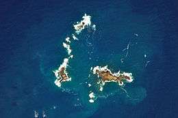 Satellite image of part of the Savage Islands with Selvagem Pequena Island (right), Fora Islet (left) and the Northern Islets (top). | |
 | |
| Geography | |
| Location | Atlantic Ocean |
| Coordinates | 30°02′N 16°03′W / 30.033°N 16.050°WCoordinates: 30°02′N 16°03′W / 30.033°N 16.050°W |
| Archipelago | Savage Islands |
| Area | 0.08 km2 (0.031 sq mi) |
| Highest elevation | 18 m (59 ft) |
| Highest point | unnamed |
| Administration | |
|
Portugal | |
| Autonomous Region | Madeira Islands |
| Demographics | |
| Population | 1 |
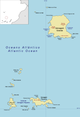
Fora Islet, in Portuguese Ilhéu de Fora ("outer islet"), is an uninhabited Portuguese island in the Atlantic Ocean, forming part of the Savage Islands, a dependant archipelago of the autonomous region of Madeira.
It lies about 300 kilometres from Madeira and 160 kilometres north of the Canary Islands. The islet (size: 500 x 300 m) has an area of 8 hectares and a maximum altitude of 18 metres.
The island is part of a nature reserve and is home to a variety of petrels (Cory's shearwater, for example). The climate is dry and there is very little soil.[1]
In 19th-century English literature, the island was called the 'Little Piton'.[2][3]
References
This article is issued from
Wikipedia.
The text is licensed under Creative Commons - Attribution - Sharealike.
Additional terms may apply for the media files.