Ibadan
| Ibadan | |
|---|---|
| Metropolis | |
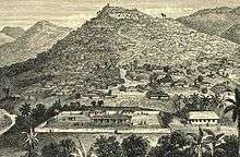
 Overlooking Ibadan (October 2016) | |
| Nickname(s): Ile Oluyole Ilu Ogunmola | |
 Ibadan Location in Nigeria | |
| Coordinates: 7°23′47″N 3°55′0″E / 7.39639°N 3.91667°ECoordinates: 7°23′47″N 3°55′0″E / 7.39639°N 3.91667°E | |
| Country |
|
| State | Oyo |
| War camp | 1829 |
| Ibadan District Council | 1961 |
| Ibadan Municipal Government | 1989 |
| Area | |
| • Metropolis | 3,080 km2 (1,190 sq mi) |
| • Urban | 6,800 km2 (2,600 sq mi) |
| Area rank | 1st |
| Elevation | 230 m (750 ft) |
| Population (2006)[1] | |
| • Metropolis | 2,559,853 |
| • Estimate (2011) | 3,034,200 |
| • Rank | 3rd |
| • Density | 985.13/km2 (2,551.5/sq mi) |
| • Urban | 3,160,000[2] |
| • Urban density | 464.71/km2 (1,203.6/sq mi) |
| • Metro | 3,500,000 (estimated) |
| Time zone | UTC+1 (WAT) |
| Climate | Tropical savanna climate (Aw) |
| Website | http://www.oyostate.gov.ng/ |
Ibadan (Yoruba: Ìbàdàn) is the capital and most populous city of Oyo State, Nigeria. With a population of over 3 million, it is the third most populous city in Nigeria after Lagos and Kano; it is the country's largest city by geographical area. At the time of Nigeria's independence in 1960, Ibadan was the largest and most populous city in the country, and the second most populous in Africa after Cairo.
Ibadan is located in south-western Nigeria, 128 km inland northeast of Lagos and 530 km southwest of Abuja, the federal capital, and is a prominent transit point between the coastal region and the areas in the hinterland of the country. Ibadan had been the centre of administration of the old Western Region since the days of the British colonial rule, and parts of the city's ancient protective walls still stand to this day. The principal inhabitants of the city are the Yorubas, as well as various communities from other parts of the country.
History
Ibadan came into existence in 1829, during a period of turmoil that characterized Yorubaland at the time. It was in this period that many old Yoruba cities such as old Oyo (Oyo ile), Ijaye and Owu disappeared, and newer ones such as Abeokuta, new Oyo (Oyo atiba) and Ibadan sprang up to replace them.[3] According to local historians, Lagelu founded the city, and was initially intended to be a war camp for warriors coming from Oyo, Ife and Ijebu.[4] As a forest site containing several ranges of hills, varying in elevation from 160 to 275 metres, the location of the camp offered strategic defence opportunities. Moreover, its location at the fringe of the forest (from which the city got its name) promoted its emergence as a marketing centre for traders and goods from both the forest and grassland areas.
In 1852 the Church Missionary Society sent David and Anna Hinderer to found a mission. They decided to build the mission and a church in Ibadan when they arrived in 1853.[5]
Ibadan thus had initially begun as a military state and remained so until the last decade of the 19th century. The city-state also succeeded in building a large empire from the 1860s to the 1890s which extended over much of northern and eastern Yorubaland. It was appropriately nicknamed idi Ibon or “gun base”, because of its unique military character.[6]
Unlike other Yoruba cities with traditional kingship institutions however, In Ibadan, the warrior class became the rulers of the city as well as the most important economic group. According to HRH Sir Isaac Babalola Akinyele, the late Olubadan (king) of Ibadan (Olu Ibadan means 'Lord of Ibadan'), in his authoritative book on the history of Ibadan, Iwe Itan Ibadan (1911), the first city was destroyed due to an incident at an Egungun (masquerade) festival when an Egungun was accidentally disrobed and derisively mocked by women and children in an open marketplace full of people. The Alaafin of Oyo of that time ordered the old city destroyed for the act. Lagelu could not stop the destruction of his city, but he and some of his people survived the attack and fled to a nearby hill for sanctuary. The new city instantly grew prosperous and became a commercial centre. The newly enthroned Olubadan made a friendly gesture to the Olowu of Owu by allowing Olowu to marry his only daughter, Nkan. A part of Ibadan was historically an Egba town. The Egba occupants were forced to leave the town and moved to present-day Abeokuta under the leadership of Sodeke as a result of their disloyalty.
Ibadan grew into an impressive and sprawling urban center so much that by the end of 1829, Ibadan dominated the Yorùbá region militarily, politically and economically. The military sanctuary expanded even further when refugees began arriving in large numbers from northern Oyo following raids by Fulani warriors. After losing the northern portion of their region to the marauding Fulanis, many Oyo indigenes retreated deeper into the Ibadan environs. The Fulani Caliphate attempted to expand further into the southern region of modern-day Nigeria, but was decisively defeated by the armies of Ibadan in 1840, which eventually halted their progress. The colonial period reinforced the position of the city in the Yoruba urban network. After a small boom in rubber business (1901-1913), cocoa became the main produce of the region and attracted European and Levantine firms, as well as southern and northern traders from Lagos, Ijebu-Ode and Kano among others. The city became a major point of bulk trade. Its central location and accessibility from the capital city of Lagos were major considerations in the choice of Ibadan as the headquarters of the Western Provinces (1939) which ranged from the northernmost areas of Oyo State to Ekeremor, Bomadi and Patani, which were regions transferred from the old Delta province in the Old Western region and later Mid-west to the old Rivers state and later Bayelsa, in the redistricting of Nigeria carried out by the Yakubu Gowon administration shortly before the Nigerian civil war
Colonial Ibadan
In 1893, Ibadan area became a British Protectorate after a treaty signed by Fijabi, the Baale of Ibadan with the British acting Governor of Lagos Colony, George C. Denton on 15 August.[7] By then, the population had swelled to 120,000. The British developed the new colony to facilitate their commercial activities in the area, and Ibadan shortly grew into the major trading center that it is today.
Geography
Ibadan is located in south-western Nigeria in the southeastern part of Oyo State at about 119 kilometres (74 miles) northeast of Lagos and 120 kilometres (75 miles) east of the Nigerian international border with the Republic of Benin. It lies completely within the tropical forest zone but close to the boundary between the forest and the derived savanna. The city ranges in elevation from 150 m in the valley area, to 275 m above sea level on the major north-south ridge which crosses the central part of the city. The city covers a total area of 3,080 square kilometres (1,190 sq mi), the largest in Nigeria.
The city of Ibadan is naturally drained by four rivers with many tributaries: Ona River in the North and West; Ogbere River towards the East; Ogunpa River flowing through the city and Kudeti River in the Central part of the metropolis. Ogunpa River, a third-order stream with a channel length of 12.76 km and a catchment area of 54.92 km2. Lake Eleyele is located at the northwestern part of the city, while the Osun River and the Asejire Lake bounds the city to the east.
Climate
Ibadan has a tropical wet and dry climate (Köppen climate classification Aw), with a lengthy wet season and relatively constant temperatures throughout the course of the year. Ibadan’s wet season runs from March through October, though August sees somewhat of a lull in precipitation. This lull nearly divides the wet season into two different wet seasons. November to February forms the city’s dry season, during which Ibadan experiences the typical West African harmattan. The mean total rainfall for Ibadan is 1420.06 mm, falling in approximately 109 days. There are two peaks for rainfall, June and September. The mean maximum temperature is 26.46 C, minimum 21.42 C and the relative humidity is 74.55%.
| Climate data for Ibadan | |||||||||||||
|---|---|---|---|---|---|---|---|---|---|---|---|---|---|
| Month | Jan | Feb | Mar | Apr | May | Jun | Jul | Aug | Sep | Oct | Nov | Dec | Year |
| Record high °C (°F) | 37.2 (99) |
38.9 (102) |
38.3 (100.9) |
37.2 (99) |
35.0 (95) |
33.3 (91.9) |
31.7 (89.1) |
31.7 (89.1) |
35.6 (96.1) |
33.3 (91.9) |
33.9 (93) |
35.6 (96.1) |
38.9 (102) |
| Average high °C (°F) | 32.3 (90.1) |
34.0 (93.2) |
33.5 (92.3) |
32.3 (90.1) |
31.2 (88.2) |
29.6 (85.3) |
27.8 (82) |
27.2 (81) |
28.5 (83.3) |
29.7 (85.5) |
31.3 (88.3) |
31.9 (89.4) |
30.8 (87.4) |
| Daily mean °C (°F) | 25.7 (78.3) |
26.9 (80.4) |
26.9 (80.4) |
26.3 (79.3) |
25.6 (78.1) |
25.1 (77.2) |
23.6 (74.5) |
23.1 (73.6) |
23.9 (75) |
24.3 (75.7) |
25.6 (78.1) |
25.5 (77.9) |
25.2 (77.4) |
| Average low °C (°F) | 20.9 (69.6) |
21.9 (71.4) |
22.5 (72.5) |
22.0 (71.6) |
21.7 (71.1) |
21.6 (70.9) |
21.2 (70.2) |
20.7 (69.3) |
21.8 (71.2) |
21.7 (71.1) |
21.6 (70.9) |
20.7 (69.3) |
21.5 (70.7) |
| Record low °C (°F) | 10.0 (50) |
11.1 (52) |
15.0 (59) |
18.3 (64.9) |
17.8 (64) |
17.8 (64) |
16.1 (61) |
15.6 (60.1) |
17.2 (63) |
17.8 (64) |
15.6 (60.1) |
11.1 (52) |
10.0 (50) |
| Average rainfall mm (inches) | 10 (0.39) |
25 (0.98) |
91 (3.58) |
135 (5.31) |
152 (5.98) |
188 (7.4) |
155 (6.1) |
86 (3.39) |
175 (6.89) |
160 (6.3) |
46 (1.81) |
10 (0.39) |
1,233 (48.54) |
| Average rainy days (≥ 0.3 mm) | 1 | 3 | 7 | 9 | 14 | 17 | 15 | 13 | 18 | 18 | 7 | 1 | 123 |
| Average relative humidity (%) | 76 | 73 | 77 | 82 | 85 | 87 | 89 | 88 | 88 | 87 | 83 | 79 | 83 |
| Mean monthly sunshine hours | 198.4 | 197.8 | 186.0 | 180.0 | 195.3 | 147.0 | 86.8 | 65.1 | 93.0 | 164.3 | 207.0 | 220.1 | 1,940.8 |
| Mean daily sunshine hours | 6.4 | 7.0 | 6.0 | 6.0 | 6.3 | 4.9 | 2.8 | 2.1 | 3.1 | 5.3 | 6.9 | 7.1 | 5.3 |
| Source: Deutscher Wetterdienst[8] | |||||||||||||
Administration
There are eleven (11) Local Governments in Ibadan Metropolitan area consisting of five urban local governments in the city and six semi-urban local governments in the less city. Local governments at present are institutions created by the military governments but recognised by the 1999 constitution and they are the third tiers of government in Nigeria. Local governments Councils consist of the Executive Arm made up of the Executive Chairman, the Vice chairman, the Secretary and the Supervisory Councilors.[9]
Local Government Areas
Ibadan Urban — LGA Chairman
- Ibadan North — Adebayo Adegoke
- Ibadan North-East — Lekan Afuye
- Ibadan North-West — Mojeed Bosun Ajuwon
- Ibadan South-East — Abimbola Omiyale
- Ibadan South-West — Adeleke Taoreed Bolaji
Ibadan Semi-Urban — Chairman
Local Council Development Areas
The current Executive Governor of Oyo State, Senator Isiaka Abiola Ajimobi, recently created some Local Council Development Areas (LCDAs) out of some of the existing local government areas in Oyo State. From the Ibadan Urban Local Government areas, the following LCDAs were created. Out of Ibadan North Local Government area, Aare Latosa LCDA and Irepodun LCDA were created. Out of Ibadan North East Local Government area, Ibadan East LCDA was created. Out of Ibadan North West Local Government area, Oke'Badan North LCDA was created. Out of Ibadan South East Local Government area, Ibadan South LCDA was created. Out of Ibadan South West Local Government area, Ibadan West LCDA was created. [[citations needed]]
From the Ibadan Semi-urban Local Government areas, the following LCDAs were created. Out of Akinyele Local Government area, Akinyele South LCDA and Akinyele East LCDA were created.
Population
Demographics
Until 1970, Ibadan was the largest city in Sub-Saharan Africa by surface.[3] In 1952, it was estimated that the total area of the city was approximately 103.8 km2[10] However, only 36.2 km2 was built up. This meant that the remaining 67 km2 were devoted to non-urban uses, such as farmlands, river floodplains, forest reserves and water bodies. These “non-urban land uses” disappeared in the 1960s: an aerial photograph in 1973 revealed that the urban land-scape had completely spread over about 100 km2. The land area increased from 136 km2 in 1981 to 210–240 km2 in 1988-89 (Areola, 1994: 101). By the year 2000, it is estimated that Ibadan covered 400 km2.[11] The growth of the built-up area during the second half of the 20th century (from 40 km2 in the 1950s to 250 km2 in the 1990s) shows clearly that there has been an underestimate of the total growth of the city. In the 1980s, the Ibadan-Lagos expressway generated the greatest urban sprawl (east and north of the city), followed by the Eleiyele expressway (west of the city). Since then, Ibadan city has spread further into the neighbouring local government areas of Akinyele and Egbeda in particular.
Religion
Islam and Christianity are the dominant religions practiced in Ibadan with the overwhelming majority of the core Ibadan City Center inhabitants being Muslims. Christianity is also spread all across this core city to the suburbs. Next to the Olubadan's palace is the gigantic mosque where the Chief Imam holds his Friday jumu'ah service sermons. Ibadan's Cathedral of St. Mary is the episcopal see of the Metropolitan Roman Catholic Archdiocese of Ibadan, whose ecclesiastical province includes four suffragans bishoprics: Ekiti, Ilorin, Ondo, Osogbo and Oyo.
Furthermore, its Church of Our Lady of the Annunciation is the cathedral see of the Maronite Eparchy of the Annunciation,[12] which is exempt (i.e. directly dependent on the Holy See), serves as Apostolic Visitor for Maronites in Southern Africa (where they have no ordinary) and follows the Antiochian Rite. There is also large baptist presence with the First Baptist Church located at idikan Street. There are also Oritamefa Baptist Church and molete Baptist Church with imposing structures in there locations.
Traditional Yoruba religion is also very important in the city of Ibadan. There are numerous priests and priestesses of the Yoruba deities known as Orisa throughout, and some of the oldest compounds have shrines to both popular as well as local divinities that were brought from many different parts of Yorubaland. The Oke Ibadan festival is one of many festivals for indigenous Yoruba spirituality that draw pilgrims from many parts of Yorubaland in Nigeria as well as Benin Republic. Other important orisa festivals include the Egungun festival which celebrates the ancestors with masquerades, drumming, singing, and dancing, as well as the Yemoja festival, and the Ose Meji festival for the deity Orunmila along with the spirit called Ela. Ose Meji is from the Ifa sacred literary corpus that founded the city of Ibadan when divination was performed at its early settlement. The city has many Babalawo (priests of Ifa or the deity known as Orunmila), Yemoja priests, Egungun priests, Ogboni priests, Esu priests, Ogun priests, and various others of the Yoruba pantheon.
Monuments, landmarks and other locations
The best method to move about the city is to use reference points and notable landmarks.
Dugbe district is the commercial nerve centre of Ibadan. This is where many banks have one or more branches. The south west regional office of the Central Bank of Nigeria is at Dugbe. Also at Dugbe is the Cocoa House,[13] Nigeria's first skyscraper.
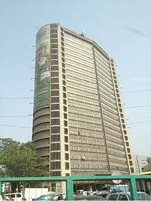
It is one of the few skyscrapers in the city and is at the hub of Ibadan's commercial centre. Cocoa house is the headquarters for the Oodua Investment Company co-own by all south-western states. Other tall buildings around Dugbe axis include Femi Johnson glass house, CBN building, United Bank for Africa, Oxford building, Federal Radio Corporation of Nigeria's Building, among others.
There is a museum in the building of the Institute of African Studies, which exhibits several remarkable pre-historic bronze carvings and statues. The city has several well stocked libraries, and is home to the first television station in Africa. The city has two zoological gardens, one located within the University of Ibadan and another at Agodi Gardens which also contains a botanical garden, swimming pool and leisure spots.
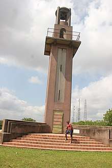
The Bower Memorial Tower[14] to the east on Oke Aàre (Aare's Hill) ("Aare" in Yoruba means commander-in-chief or generalissimo), which can be seen from practically any point in the city; it also provides an excellent view of the whole city from the top. Other attractions include Mapo Hall[15] – the colonial style city hall – perched on top of a hill, "Oke Mapo," Mapo Hill ("oke" is hill in Yoruba), the Trans-Wonderland amusement park, the cultural centre Mokola and the Obafemi Awolowo Stadium (formerly Liberty Stadium). The first citadel of higher learning, University of Ibadan (formerly the University College of Ibadan), the Obafemi Awolowo Hall in the university of Ibadan is said to be the tallest and largest hostel in west Africa. The first teaching hospital in Nigeria, University College Hospital, were both built in this ancient city. Ibadan is also home to the Shooting Stars FC – a professional Football Club also known as 3SC.
There are some good golf courses: the Ibadan Golf Club is a large 18-hole challenge and the Barracks course has just been extended to 18 holes. The most challenging and exclusive is the 9-hole IITA Golf Club based on the 1,000 hectare premises of IITA.
Education
Ibadan is host to Nigeria's premier higher institution of learning, The University of Ibadan. Established as a college of the University of London in 1948, and later converted into an autonomous university in 1962, it has the distinction of being one of the premier educational institutions in Africa. Other higher educational institutions in the city include; The Polytechnic, Ibadan, Lead City University,Koladaisi University, Federal college of Animal health and Production Technology, Federal College of Forestry, Highland College of Technology, Samonda,Federal School of Statistics, Tower Polytechnic, Ibadan, Ibadan City Polytechnic, Citigate Polytechnic, NIIT University among others.
There are also numerous public and private primary and secondary schools located in the city and its suburbs. Other noteworthy institutions in the city include The University College Hospital, Ibadan (UCH), which is the first teaching hospital in Nigeria; the internationally acclaimed International Institute of Tropical Agriculture (IITA) headquartered in the city. Established in 1967, it focuses on the agricultural and developmental needs of tropical countries, with several research stations spread across Africa. The Nigerian Institute of Social and Economic Research (NISER), The Cocoa Research Institute of Nigeria, The National Root Crops Research Institute, and The Institute of Agricultural Research and Training (IAR&T), The Forestry Research Institute of Nigeria, The Nigerian Horticultural Research Institute (NIHORT), all under the auspices of The Agricultural Research Council of Nigeria.[16]
Before the dissolution of the Western Region, Nigeria, Ibadan and its environs were the home of the most sophisticated and liberal scientific and cultural community on the continent of Africa, as personified by the immortalized Ibadan School of historiography.
In 1853, the first Europeans to settle in Ibadan, Reverend David and Anna Hinderer, started Ibadan's first Western schools. They built churches and Anna taught at the new school.[5] They built the first two-storey building in Ibadan, which can still be found today at Kudeti. The first pupils to attend an elementary school in Ibadan were Yejide Olunloyo (female) and Akinyele Olunloyo (male) – the two children of an Ibadan high chief.
Economy
Ibadan is the capital city of Oyo State, the fourth largest state economy in Nigeria,[17] and the second largest non-oil state economy in Nigeria after Lagos state. With its strategic location on the railway line connecting Lagos to Kano,[18] the city is a major center for trade in cassava, cocoa, cotton, timber, rubber, and palm oil. The city and its environs is home to several industries such as Agro allied, Textile, Food processing, Health Care and Cosmetic, Tobacco processing and Cigarette manufacturing, Leatherworks and furniture making Etc. There is abundance of clay, kaolin and aquamarine in the city environs, and there are several cattle ranches, a dairy farm as well as a commercial abattoir in Ibadan. There are dozens of banks and Insurance firms spread out across the cityscape that service the city's millions of inhabitants.
The main economic activities engaged in by the Ibadan populace include Agriculture, Trade, Public service employment, Factory work, Service sector/Tertiary production, Etc. The headquarters of the International Institute of Tropical Agriculture (IITA) have extensive grounds for crop and agricultural research into key tropical crops such as bananas, plantains, maize, cassava, soybean, cowpea and yam.[19] According to a report, Ibadan is the 3rd cheapest Nigerian city to live in.[20]
Entertainment and Media
Ibadan is a busy city but also accommodates an adequate amount of entertainment and relaxation. There are numerous bars, lounges and night clubs to enjoy, including the Lebanese owned "KOKO Dome" which is the oldest night club in the city dating back to the mid 90s. These are the clubs you get the nightlife, unwind moments, ladies nites, dancing, sashaying, strippers, splurging on drinks and more. Clubs: GQ Lounge- Old Bodija Ebevande- Challenge Bubbles-Challenge Spyda- Agbowo Coded Lounge- Challenge Clique 69- Ring Road Koko Dome- Cocoa House, Dugbe Options 24/7 (Formerly known as Yepaa)- Ikolaba, Agodi GRA Time Out-Oluyole Chillarz-Oluyole Club Ace Olympus X-Queen Cinema, Dugbe 411- Sango-Bodija Road Apollos- Ringroad Echo Blues - Ringroad Topside Lounge - Ringroad/Oluyole E3- Ringroad Infinities- Ringroad.[21]
The hotels also ranging in class and styles and according to budgets. Top hotels include Premier Hotel Mokola Hill, Travel House, A3 Hotels, Wallan Hotel, Davies Hotel, Labod Hotel, Kakanfo Inn, and Lafia Hotel.
Shopping, Cinema and Parks
The Heritage Mall and Cocoa Mall houses several local and international retail stores the two malls built to interlink each other is located in the same compound as coco house at Dugbe. The 2 malls contain a South African retail shop; Shoprite, Pep Store (kids wears and boutique) several cafés, restaurants, electronic outlets, Mr price, Cash n Carry. The newly opened Ibadan City Mall houses the largest Shoprite store in Nigeria there are other stores within too. The Filmhouse has cinemas in the heritage mall and another of it branch operate at the Ventura mall, Sango area north of the city as principal tenant.
Sports and Recreation
There are various sport centres and facilities within the city limits of Ibadan. The Ibadan recreational club established 1902 in the Sabo area of the city is one of the oldest of such clubs in the country. It offers a Swimming pool, Tennis courts, Basketball courts, Snooker, Squash courts, Darts corner, and a relaxation bar. The city is also host to dozens of football academies where soccer talents are groomed. The Agodi Gardens of Oyo State has been completely refurbished to contain a Botanical Garden, Zoo, Swimming pool, Guest house, Bar and Restaurants. In addition, there are the Ibadan Polo Club at Eleyele and the Ibadan Golf Club[22] in the Onireke reservation Area. Various fitness centres can be found around the city, such as: The lora gym centre, Oyo state executive gym, The Ibadan gym, Mocdim health & fitness centre, Etc.
The city has the first standard Nigerian stadium, The Obafemi Awolowo Stadium formerly Liberty Stadium as well as The Lekan Salami Stadium which is the home of 3SC, Shooting stars football club, the team that won Nigeria's first international trophy, The African Cup Winners' Cup in 1976 by defeating Tonnerre Yaoundé of Cameroon 4 - 2 on aggregate points.
Public space and Parks
- Trans Amusement park
- Fun factory
- Agodi Gardens and Leisure Park
- Heritage Mall
- Ibadan recreational park
- Shoprite mall in cocoa house dugbe
- The Palms shopping mall
- Ventura Mall and Indoor park
Transport
The city of Ibadan is a major Nigerian transport hub with freeways linking it with Lagos in the South South West, Ijebu Ode and Shagamu in the South, Abeokuta in the West, Oyo, ogbomosho, Offa and Ilorin in the North, Ife, Ado Ekiti, Osogbo, Ilesha, Akure, Okene, Auchi and other cities towards the East. The city is also served by an airport, The Ibadan Airport, which operates daily flights to Abuja, Lagos, Kano, Ilorin etc. through major airlines in Nigeria such as Overland Airways and Arik Air. The city is a major terminus railway station on the main railway line linking Lagos with Kano in the North of the country. Nearly all the major roads are dualized (Double carriage roads), such roads include the Ojoo-Sango-Mokola road that passes in front of the University of Ibadan, others include Ring road-Orita-Challenge-New Garage ways and the recently completed Dugbe-Eleyele-Jerico Road. There are various roundabouts, intersections and flyovers within the city, the latest being the Mokola flyover built to reduce persistent traffic gridlock being experienced in the Mokola axis of the city.
Modes of transport include, cabs & taxis, taxi-vans commonly called Danfos, and in more recent times mass transit buses have commenced operations to reduce the hardship of students and workers commuting from various suburban areas to the city center, private/personal/family cars, scooters commonly known as Okadas, Coach (bus) services, more commonly known locally as "luxurious busses" such as Alakowe Bus, ABC Transport, Cross Country ltd Etc., which operate To and Fro services linking Ibadan and all other major destinations in the country and beyond, as well as pedestrian walking.
Media
The city host the first T.V station in Africa NTA, Ibadan established as western Nigeria Television (WNTV) in 1959. The oldest surviving Nigeria newspaper is in Ibadan Tribune founded by chief Obafemi Awolowo premier of western Nigeria. The first private TV station Galaxy tv in Oyo State also started in the city. As at 2014 the city is home to several media outlets including
- NTA Ibadan Network Centre
Galaxy TV
- B.C.O.S Broadcasting Corporation of Oyo State which also runs the radio services of B.C.O.S radio 1, Oluyole fm 98.5)
- MITV, Ibadan
- Silverbird TV
- Channels tv
- AIT Africa Independent Television
Satellite channels are provided by
- Multichoice Africa owner of DStv and GOTV satellite company has an office in the Jericho area of the city providing subscribers with numerous international and local TV and radio.
- Star times
- DaarSat
The radio stations in Ibadan are increasing in number compared to 5–10 years ago, when only 3 operated. Today, there are:
- B.C.O.S radio 1 and Oluyole fm 98.5
- Premier fm 93.5 (federal government)
- Amuludun fm 99.1(Yoruba only, federal government)
- Beat fm 97.9
- Mitv/Star fm 95.1
- Raypower radio of AIT
- Diamond fm 101.1 of University of Ibadan
- Impact Business Radio (IBR 92.5 FM) a.k.a. Amutajero
- Splash fm 105.5
- Inspiration fm 100.5
- Space fm 90.10
- Naija fm 102.7
- Royal Roots (R2)fm 92.9
- Petals fm 102.3
- Lagelu fm 96.3
- Fresh fm 105.9
- Star fm 91.5
There are also online communities of Ibadan residents such as CONNECTIBADAN and www.WhatsupIbadan.com. They help the public connect with news, event and people in Ibadan and Oyo State as a whole.
Twin towns – sister cities
Ibadan is twinned with:
See also
References
- ↑ Summing the 11 Local Government Areas of Ibadan using:
population.de (2011). "Population of oyo state". Retrieved 15 July 2016. - ↑ Demographia (January 2015). Demographia World Urban Areas (PDF) (11th ed.). Retrieved 2 March 2015.
- 1 2 Lyold, P.C et.al (1967). The City of Ibadan. Cambridge University Press. ISBN 978-0-521-11217-8.
- ↑ "Ibadan History". Litcaf. 2016-02-12. Retrieved 2017-06-04.
- 1 2 Martin Lynn, ‘Hinderer , Anna (1827–1870)’, Oxford Dictionary of National Biography, Oxford University Press, 2004 accessed 18 March 2017
- ↑ http://www.ucl.ac.uk/dpu-projects/Global_Report/pdfs/Ibadan.pdf
- ↑ Olufemi Vaughan. Nigerian Chiefs: Traditional Power in Modern Politics, 1890s-1990s.
- ↑ "Klimatafel von Ibadan / Nigeria" (PDF). Baseline climate means (1961-1990) from stations all over the world (in German). Deutscher Wetterdienst. Retrieved 14 July 2016.
- ↑ Tomori M. A. "IBADAN METROPOLITAN AREA AND THE CHALLENGES TO SUSTAINABLE DEVELOPMENT".
- ↑ Areola, O. "The Spatial Growth of Ibadan City and its impact on the rural Hinterland" in M.O. Filani, F.O. Akintola and C.O. Ikporukpo edited Ibadan Region, Rex Charles Publication, Ibadan, 1994 page 99.
- ↑ Onibokun, P. and Faniran A., Urban research in Nigeria. IFRA and CASSAD, Ibadan, 1995
- ↑ "Resignations and Appointments". press.vatican.va. Retrieved 2018-06-01.
- ↑ "Ibadan travel guide". World66.com. Retrieved 2014-02-18.
- ↑ "The Bower Memorial Tower on wikimapia". Wikimapia.org. Retrieved 2014-02-18.
- ↑ "Wikimapia - Let's describe the whole world!". Retrieved 26 June 2016.
- ↑ "National Agricultural Research Institutes". ARCH. Archived from the original on 21 June 2010. Retrieved 10 August 2009.
- ↑ "oyo - Services Portal". Retrieved 26 June 2016.
- ↑ "Can Nigeria's renovated railway unite north and south?". Retrieved 26 June 2016.
- ↑ IITA. "International Institute of Tropical Agriculture (IITA)". / Cgiar. Retrieved 2014-02-18.
- ↑ IbadanGists. "Ibadan is the 3rd Cheapest Nigerian City to Live in". / IbadanGists. Retrieved 2014-11-17.
- ↑ Christina Adegbaju. "Ibadan popular clubs and hangouts". / Typearls. Retrieved 2015-09-14.
- ↑ "Home". Retrieved 26 June 2016.
- ↑ "Sister Cities International (SCI)". Sister-cities.org. Archived from the original on 13 June 2015. Retrieved 21 April 2013.
- 'On Education' - Page 69; 'Seventeen Years in the Yoruba Country: Memorials of Anna Hinderer (wife of the Rev. David Hinderer, C.M.S. Missionary in Western Africa).
Bibliography
External links
| Wikimedia Commons has media related to Ibadan. |