Huvadhu Atoll
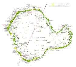
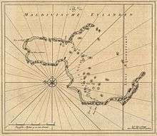
Huvadhu is a large atoll located south of the Suvadiva Channel the Republic of Maldives. With a total area of 3152 km², of which 38.5 km² is dry land, it is the second largest geographical atoll in the country, after Boduthiladhunmathi (consisting of Haa Alif, Haa Dhaalu, Shaviyani, and Noonu administrative divisions.)
In terms of number of islands, it is the largest atoll in the world with 255 islands.
Huvadu Atoll has been divided into two districts (administrative atolls) for local administrative purposes since the 1970s. These divisions are Northern Huvadhu Atoll (Gaafu Alifu) in the north, and Southern Huvadhu Atoll (Gaafu Dhaalu).
The traditional seat of power in the Huvadhu was Thinadhoo up until the division, after which Thinadhoo remained the Capital of South Huvadhu Atoll, and Villingili was instated as the capital of North Huvadhu Atoll.
The best quality mats of the Maldives are woven in this atoll, in the island of Gaddū. The local grass 'hau' is dyed in two colors, black and yellow.
History
The ancient Sanskritised name of this atoll was Suvadive. Its capital and most important island was Tinadū ( Thinadhoo (Gaafu Dhaalu Atoll) ). Thinadhoo was occupied with Malé militia for years prior to the Suvaldive uprising and thus commonly referred to the island during that era as Havaru Tinadu. The term havaru means 'militia' in dhivehi.
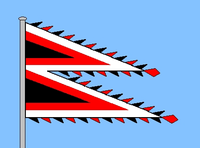
Historically the Huvadu atoll chief based in Tinadu had a great measure of self-government. He even had the privilege, not granted to any other atoll chief of the Maldives, to fly his own flag in his vessels and at his residence. The flag of the Huvadu Atoll Chief was similar to the flag of Nepal in cut, with two central black triangles edged by red and white bands.[1]
There are many Buddhist archaeological remains in Huvadū. Therefore, it is likely that this was a very important Atoll in that period of Maldivian History. None of these ancient remains have been properly investigated yet.[2]
Due to its strategic placement on the main sea route around southern India, Huvadhu and the other southern atolls have a long history of contact from mariners sailing the Indian Ocean through the centuries.[3]
Descendants of Diyamigili & Isdhoo Dynasty
Families of Dhiyamigili and Isdhoo Dynasty can be traced to Devvadu, Addu, Fuvahmulah and Tinadu. After the murder of Muhammed Ghiya'as ud-din, Prince Abdulla son of Ghiyaasuddin was banished to Fuvahmulah. The South of Maldives was a safe haven for Abdulla who was recognized and looked after well as he already had relatives in the region, being a descendant of Addu Bodu Fandiyaaru Thakurufaan.
Devvadhoo Rasgefaanu
Dhevvadhoo island strategically located at the centre of the Huvadu atoll was the throne island of Mohamed IV popularly known as Devvadhoo Rasgefaanu, progenitor of Isdhoo Dynasty. Devvadhoo Rasgefaanu was the first Sultan of Isdhoo Dynasty who was the son of Ali Mafahaiy Kilege of Devvadu and Kakuni Dio[4]. Sultan Mohamed IV was married to Khadheeja Kan’ba, daughter of Ibrahim Shah Bandar also known as Isdhoo Bodu Velaanaa Thakurufaan.
Secession of the Suvadive Islands
In January 1959, the three southern atolls: Huvadhu, Fuvahmulah and Addu, were involved in setting up the breakaway United Suvadive Republic which survived until September 1963. The name of the secessionist state was taken from the ancient name of this atoll.
In some islands, like Gaddhoo, there was opposition to the secession, however through threats and coercion, the groups of people opposing the Suvadive state were forced to agree.
The republic collapsed when the island of Havaru Thinadhoo was depopulated, and all infrastructure burnt to the ground by the Maldivian military lead by then Prime Minister Ibrahim Nasir in 1962, after which it was left uninhabited for four whole years. For the next 10 years, the seat of power was moved to Gaddhoo until Havaru Thinadhoo, since repopulated, was reinstated as the capital of Huvadhoo.
The main motivation for secession was stated to be disagreements with the centralized policies that were being enforced by Male' at the time.
Huvadu Kandu
The name of the broad channel north of this atoll is locally known as Huvadu Kandu. It appeared on the old French maps as Courant de Souadou. Other names are Suvadiva Channel or One-a-half Degree Channel.
It is named after Huvadu Atoll and is the broadest channel between the atolls of Maldives.
Language
The inhabitants of this large atoll speak their own distinct form of the Dhivehi language, known as Huvadu Bas.
Because of the isolation from the Northern Atolls, and the capital of Malé, the local dialect Huvadhu bas is significantly different from the other variants of the Maldive language, making much use of the retroflex 'Ţ' and allegedly retaining old forms of Dhivehi. Huvadhu Bas also retains old Sinhala words, is considered to be closer to Sinhala than the other dialects of Dhivehi.
References
- ↑
- Divehi Tārīkhah Au Alikameh. Divehi Bahai Thagaafa Khiduma kura Qawmi Majlis. Male'.
- ↑ Xavier Romero-Frias, The Maldive Islanders, A Study of the Popular Culture of an Ancient Ocean Kingdom. 1999, ISBN 84-7254-801-5
- ↑ Camerapix (1999). Spectrum Guide to Maldives. Brooklyn: Interlink Books. ISBN 1-56656-290-2.
- ↑ http://www.royalark.net/Maldives/maldive9.htm The Devadhu Dynasty
- Divehiraajjege Jōgrafīge Vanavaru. Muhammadu Ibrahim Lutfee. G.Sōsanī. Malé 1999.
- The Islands of Maldives. Hasan A. Maniku. Novelty. Malé 1983.
- H.C.P. Bell, The Maldive Islands, An account of the Physical Features, History, Inhabitants, Productions and Trade. Colombo 1883.
- H.C.P. Bell, The Maldive Islands; Monograph on the History, Archaeology and Epigraphy. Reprint Colombo 1940. Council for Linguistic and Historical Research. Male’ 1989
- Xavier Romero-Frias, The Maldive Islanders, A Study of the Popular Culture of an Ancient Ocean Kingdom. 1999, ISBN 84-7254-801-5
- Skjølsvold, Arne. Archaeological Test-Excavations On The Maldive Islands. The Kon-Tiki Museum Occasional Papers, Vol. 2. Oslo 1991.
- "Reinventing MDP". HaveeruOnline. 2007. Archived from the original on 2007-02-21. Retrieved 2007-01-19.
External links
See also
- United Suvadive Republic
- List of sultans of the_Maldives
- Isdhoo dynasty
- Dhiyamigili dynasty
- Atolls of the Maldives
- Saleem Ali
First-level administrative divisions of the Maldives | ||
|---|---|---|
| Atolls |  | |
| Cities | ||