Hotoke-ga-ura
| Hotokegaura (仏ヶ浦) | |
| Protected Area | |
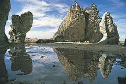 typical rock formations at Hotokegaura | |
| Country | Japan |
|---|---|
| Prefecture | Aomori Prefecture |
| District | Shimokita |
| Village | Sai |
| Coordinates | 41°18′43.9″N 140°48′18.4″E / 41.312194°N 140.805111°E |
| Place of Scenic Beauty Natural Monument of Japan |
April 23, 1941 |
| IUCN category | III - Natural Monument |
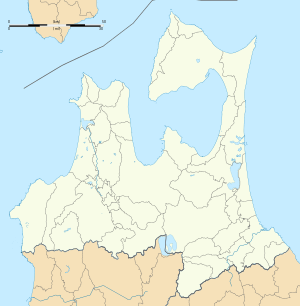 Location of Hotokegaura  Hotoke-ga-ura (Japan) | |
Hotokegaura (仏ヶ浦 also 仏宇多 Hotoke-ga-ura) is a series of rock formations along the sea cliffs on the west coast of Shimokita Peninsula at the entrance to Mutsu Bay in far northern Japan. These natural formations are made from green volcanic tuff, with a height of approximately 90 metres (300 ft) and extend for a 1.5 kilometres (0.93 mi) stretch of coastline in the village of Sai, Aomori Prefecture. Individual features have been named for figures in Buddhist theology, and were popularised by the poet and mountaineer Omachi Keigetsu (1869-1925) after his visit in September 1922, although the area had been well-known since the Edo period at part of the pilgrimage route to Mount Osore.
These rock formations were designed a Natural Monument of Aomori Prefecture in 1934, and became further protected from April 23, 1941 as a nationally designated Place of Scenic Beauty and Natural Monument,[1][2] From 1968, the rock formations were also located within the borders of the Shimokita Hantō Quasi-National Park.
See also
Gallery
.jpg) Panorama
Panorama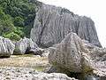 Rock formations
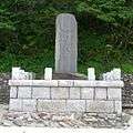 Monument to Omachi Keigetsu
References
- Teikoku's Complete Atlas of Japan, Teikoku-Shoin Co., Ltd. Tokyo 1990, ISBN 4-8071-0004-1
External links
| Wikimedia Commons has media related to Hotokegaura. |
Notes
- ↑ "仏宇多 (仏ヶ浦)". Agency for Cultural Affairs. Retrieved 10 February 2012.
- ↑ "Hotokegaura". Aomori Prefecture. Retrieved 10 February 2012.