Hornberg Basin
| Hornberg Basin | |
|---|---|
 Hornberg Basin - Upper storage reservoir of the Wehr pumped hydropower station | |
| Location | Landkreis Waldshut |
| Construction began | 1970–1975 |
| Dam and spillways | |
| Height (foundation) | 65 m |
| Height (thalweg) | 65 m |
| Length | 1715 m |
| Elevation at crest | 1050.00 m |
| Width (crest) | 5 m |
| Dam volume | 2200000 m3 |
| Reservoir | |
| Active capacity | 4.4 million m³ |
| Surface area | 0.17 km2 |
| Maximum length | 0.700 km |
| Maximum width | 0.300 km |
| Normal elevation | 1048.00 m |
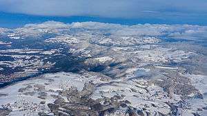
The Hornberg Basin from the air (31 Jan 2015).

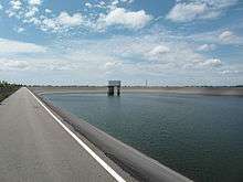
The Hornberg Basin during renovations in November 2008
The Hornberg Basin (German: Hornbergbecken) is the upper reservoir of the Wehr power station, whose lower reservoir is impounded by the Wehra Dam. It lies near Herrischried (Hornberg) and near the town of Wehr in the county of Waldshut in Baden-Württemberg on the dome of the Langer Eck, the highest hill in the Hotzenwald. It was opened in 1975, is only used to generate pumped-storage power and is operated by the Schluchseewerk.
A few hundred metres south of the Hornberg Basin it is planned to build the Hornberg Basin II by 2021 as part of the Atdorf Power Station. With a length of almost one kilometre and storage capacity of 9 million m³ it will be considerably larger than the present Hornberg Basin.
See also
References
Literature
- Festschrift Hornbergstufe der Schluchseewerk AG. November 1976
- Peter Franke, Wolfgang Frey: Talsperren in der Bundesrepublik Deutschland. DNK – DVWK 1987, ISBN 3-926520-00-0.
This article is issued from
Wikipedia.
The text is licensed under Creative Commons - Attribution - Sharealike.
Additional terms may apply for the media files.