Holderness Wapentake
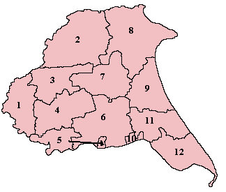
Wapentakes of the East Riding of Yorkshire. North Division is marked 9, Middle Division is marked 11 and South Division is marked 12.
Holderness was a wapentake of the historic East Riding of Yorkshire, England consisting of the south-easterly part of the county. Established in medieval times, it ceased to have much significance in the 19th century when the wapentakes were superseded by other administrative divisions for most local government purposes.
Because of its large area it was sub-divided into three divisions—North Division, Middle Division and South Division.
References
- "Relationships / unit history of Holderness". A Vision of Britain Through Time. Great Britain Historical GIS Project. Retrieved 23 July 2009.
Coordinates: 53°50′53″N 0°12′04″W / 53.848°N 0.201°W
This article is issued from
Wikipedia.
The text is licensed under Creative Commons - Attribution - Sharealike.
Additional terms may apply for the media files.