Hohe Villerspitze
| Hohe Villerspitze | |
|---|---|
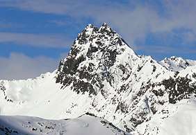 The Hohe Villerspitze from the east | |
| Highest point | |
| Elevation | 3,087 m (AA) (10,128 ft) |
| Prominence | 293 m ↓ Kleines Horntaler Joch |
| Isolation | 4.0 km → Berglasspitze |
| Coordinates | 47°06′29″N 11°10′24″E / 47.10806°N 11.17333°ECoordinates: 47°06′29″N 11°10′24″E / 47.10806°N 11.17333°E |
| Geography | |
| Parent range | Stubai Alps |
| Geology | |
| Type of rock | amphibolite |
| Climbing | |
| First ascent | 20 July 1887 by Carl Gsaller |
| Normal route | northwest arête (UIAA grade II) |

The Hohe Villerspitze is a mountain, 3,087 m (AA), in the Southeastern Sellrain Mountains (Südöstlichen Sellrainer Bergen), a sub-group of the northern Stubai Alps in the Austrian state of Tyrol. The mountain has three tops that, together, form an isolated, massive and prominent rocky summit made of amphibolite. Due to its geographic dominance and easily accessibility the Villerspitze is a fairly frequently visited lookout mountain, but it is not one to be underestimated. The southwestern rock tower has a height of 3,087 m (AA), the middle one is 3,081 m (AA) and the northwestern top is 3,024 m (AA). A prominent arête runs south from the summit.

The Hohe Villerspitze from the south
Literature and maps
- Walter Klier,Stubaier Alpen, Alpine Club Guide, Munich, 2006, ISBN 3-7633-1271-4
- Eduard Richter, Die Erschließung der Ostalpen, Vol II, Berlin, Verlag des Deutschen und Oesterreichischen Alpenvereins, 1894
- Alpine Club map 1:25,000 series, Sheet 31/2 Stubaier Alpen, Sellrain
External links

This article is issued from
Wikipedia.
The text is licensed under Creative Commons - Attribution - Sharealike.
Additional terms may apply for the media files.