Hochberg (Haardt)
| Hochberg (Haardt) | |
|---|---|
 | |
| Highest point | |
| Elevation | 636 m above sea level (NN) (2,087 ft) |
| Coordinates | 49°17′59″N 8°04′19″E / 49.29972°N 8.07194°ECoordinates: 49°17′59″N 8°04′19″E / 49.29972°N 8.07194°E |
| Geography | |
 Hochberg (Haardt) | |
| Parent range | Haardt |
The Hochberg is a 636-metre-high mountain in the central Haardt in the Palatine Forest in Germany. It lies on the territory of the municipality of Sankt Martin (Palatinate) in the county of Südliche Weinstraße in the state of Rhineland-Palatinate. After the Kalmit (673 m), the Kesselberg (662 m) and the Roßberg (637 m) it is the fourth highest peak in the Palatine Forest.
Location
The mountain lies south of two other mountains, the Breitenberg and the Hüttenberg, that are also part of the Kalmit massif and are located between the valleys of St. Martiner Tal in the north and Edenkobener Tal in the south. In addition to the main summit there is also a subpeak to the southeast, the Straußenberg (583 m). To the east the massif drops down to the Rhine Plain, its foothills including the Kropsburg (334 m), the Heidelberg (338 m) and the Werderberg (350 m) with its peace monument. To the west of the mountain is the Schafkopf (617 m), with which it is linked via a saddle by the St. Martiner Hut (486 m). On the tree-covered summit there is a stone cairn, the Steinernes Köppl. Not far from the summit is a rock outcrop, the Schornsteinfelsen, from which it is possible to see the Rhine Plain.
Access and footpaths
The mountain summit may be climbed on signed hiking trails from the Kropsburg to the east or from the Wegspinne by the St. Martiner Hut to the west.
Gallery
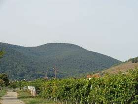
 Straußenberg
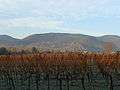
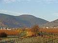 Hochberg
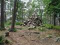 The Steinernes Köppl at the summit in summer
 The Steinernes Köppl at the summit in winter
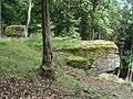 The Schornsteinfelsen rocks
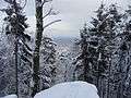 View from the Schornsteinfelsen rocks
External links
| Wikimedia Commons has media related to Hochberg (Haardt). |