Hinson's Island, Bermuda
 | |
 Hinson's Island Bermuda | |
| Location |
Hinson's Island Timlins Narrows Bermuda |
|---|---|
| Coordinates | 32°17′04″N 64°48′22″W / 32.284444°N 64.806119°W |
| Year first constructed | n/a |
| Markings / pattern | white tower with red band[1] |
| Height | 4 metres (13 ft)[1] |
| Focal height | 4 metres (13 ft)[1] |
| Light source | solar power |
| Range | 5 nautical miles (9.3 km; 5.8 mi)[1] |
| Characteristic | Fl R 2.5s.[1] |
| Admiralty number | J4506[1] |
| NGA number | 11752[1] |
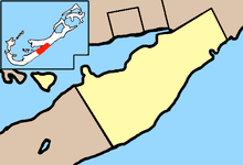
Hinson's Island is a small island within the Great Sound, Bermuda of Bermuda. It lies in the southeast of the sound, and is part of Paget parish, although it was formerly part of Warwick Parish and is still within the Warwick North constituency.
Hinson's Island is the only island in Bermuda served by the government ferry system. The population of Hinson's Island is approximately 50 people.
Hinson's (formerly known as Brown's or Godet's) Island is one of the larger islands in the Great Sound. Like its neighbours, it was used as a prisoner of war camp during the Second Boer War, then became the base for Bermuda's first seaplane service.
See also
References
Coordinates: 32°16′57″N 64°48′10″W / 32.28250°N 64.80278°W
This article is issued from
Wikipedia.
The text is licensed under Creative Commons - Attribution - Sharealike.
Additional terms may apply for the media files.