High-altitude platform station
High-altitude platform station or High-Altitude Pseudo-Satellite (short: HAPS) is – according to Article 1.66A of the International Telecommunication Union´s (ITU) ITU Radio Regulations (RR)[2] – defined as "a station on an object at an altitude of 20 to 50 km and at a specified, nominal, fixed point relative to the Earth".
Each station shall be classified by the service in which it operates permanently or temporarily.
- See also
Design considerations
Limitation due to power
A HAP can be a manned or unmanned airplane, a balloon, or an airship. All require electrical power to keep themselves and their payload functional. While current HAPS are powered by batteries or engines, mission time is limited by the need for recharging/refueling. Therefore, alternative means are being considered for the future. Solar cells are one of the best options currently being used under trial for HAPS (Helios, Lindstrand HALE).[3]
Altitude selection for HAPS
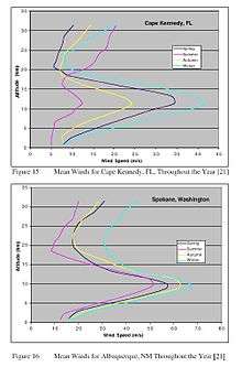
Whether an airship or an aeroplane, a major challenge is the ability of the HAP to maintain stationkeeping in the face of winds. An operating altitude between 17 and 22 km is chosen because in most regions of the world this represents a layer of relatively mild wind and turbulence above the jet stream. Although the wind profile may vary considerably with latitude and with season, a form similar to that shown will usually obtain. This altitude (> 17 km) is also above commercial air-traffic heights, which would otherwise prove a potentially prohibitive constraint.[4]
Comparison to satellites
Since HAPS operate at much lower altitudes than satellites, it is possible to cover a small region much more effectively. Lower altitude also means much lower telecommunications link budget (hence lower power consumption) and smaller round-trip delay compared to satellites. Furthermore, deploying a satellite requires significant time and monetary resources, in terms of development and launch. HAPS, on the other hand, are comparatively less expensive and are rapidly deployable. Another major difference is that a satellite, once launched, cannot be landed for maintenance, while HAPS can.[5]
Applications
Telecommunications
One of the latest uses of HAPS has been for radiocommunication service. Research on HAPS is being actively carried largely in Europe, where scientists are considering them as a platform to deliver high-speed connectivity to users, over areas of up to 400 km. It has gained significant interest because HAPS will be able to deliver bandwidth and capacity similar to a broadband wireless access network (such as WiMAX) while providing a coverage area similar to that of a satellite.
High-altitude airships can improve the military's ability to communicate in remote areas such as those in Afghanistan, where mountainous terrain frequently interferes with communications signals.[6]
Surveillance and intelligence
One of the best examples of a high-altitude platform used for surveillance and security is Northrop Grumman RQ-4 Global Hawk UAV used by the US Air Force. It has a service ceiling of 20 km and can stay in the air for continuous 36 hours. It carries a highly sophisticated sensor system including radar, optical, and infrared imagers. It is powered by a turbofan engine and is able to deliver digital sensor data in realtime to a ground station.[7]
Real-time monitoring of a region
Another future use that is currently being investigated is monitoring of a particular area or region for activities such as flood detection, seismic monitoring, remote sensing and disaster management.[8]
Weather and environmental monitoring
Perhaps the most common use of high-altitude platforms is for environment/weather monitoring. Numerous experiments are conducted through high-altitude balloons mounted with scientific equipment, which is used to measure environmental changes or to keep track of weather. Recently, NASA in partnership with The National Oceanic and Atmospheric Administration (NOAA), has started using Global Hawk UAV to study Earth's atmosphere.[9]
As a rocket launch platform
Due to the height, more than 90% of atmospheric matter is below the high-altitude platform. This reduces atmospheric drag for starting rockets. "As a rough estimate, a rocket that reaches an altitude of 20 km when launched from the ground will reach 100 km if launched at an altitude of 20 km from a balloon."[10] Such a platform has been proposed to allow the usage of (long) mass drivers for launching goods or humans into orbit.[11]
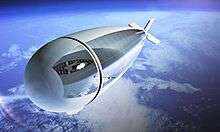
Lockheed-Martin High-Altitude Airship (HAA)
The United States Department of Defense Missile Defense Agency contracted Lockheed Martin to construct a High-Altitude Airship (HAA) to enhance its Ballistic Missile Defense System (BMDS).[12]
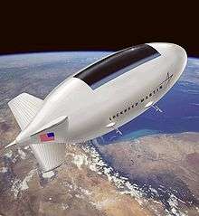
An unmanned lighter-than-air vehicle, the HAA was proposed to operate at a height of above 60,000 feet (18,000 m) in a quasi-geostationary position to deliver persistent orbital station keeping as a surveillance aircraft platform, telecommunications relay, or a weather observer. They originally proposed to launch their HAA in 2008. The airship would be in the air for up to one month at a time and was intended to survey a 600-mile (970 km) diameter of land. It was to use solar cells to provide its power and would be unmanned during its flight. The production concept would be 500 feet (150 m) long and 150 feet (46 m) in diameter. To minimize weight. it was to be composed of high strength fabrics and use lightweight propulsion technologies.
A subscale demonstrator unit for this project, the "High Altitude Long Endurance-Demonstrator" (HALE-D),[6] was built by Lockheed Martin and launched on a test flight on July 27, 2011 to demonstrate key technologies critical to the development of unmanned airships. The airship was supposed to reach an altitude of 60,000 feet (18,000 m), but a problem with the helium levels[13] occurred at 32,000 feet (9,800 m) which prevented it from reaching its target altitude, and the flight was terminated. It descended and landed at a speed of about 20 feet per second[13] in a heavily forested area in Pennsylvania.[14] Two days after the landing, before the vehicle was recovered from the crash site, the vehicle was destroyed by fire.[15]
Stratospheric airship
A stratospheric airship is a powered airship designed to fly at very high altitudes 30,000 to 70,000 feet (9.1 to 21.3 kilometres). Most designs are remote-operated aircraft/unmanned aerial vehicles (ROA/UAV). To date none of these designs have received approval from the FAA to fly in U.S. airspace.
Stratospheric airship efforts are being developed in at least five countries.[16]
The first stratospheric powered airship flight took place in 1969, reaching 70,000 feet (21 km) for 2 hours with a 5 pounds (2.3 kilograms) payload.[17] On December 4, 2005 a team led by Southwest Research Institute (SwRI), sponsored by the Army Space and Missile Defense Command (ASMDC), successfully demonstrated powered flight of the HiSentinel stratospheric airship at an altitude of 74,000 feet (23 km).[18] [19] Japan[20] and South Korea are also planning to deploy HAAs. South Korea has been conducting flight tests for several years with a vehicle from Worldwide Aeros.[21]
Aircraft
In January 2018, several systems were in development:[22]
- AeroVironment will design and development solar-powered UAV prototypes for $65 million for HAPSMobile, a joint venture 95% funded and owned by Japanese telco SoftBank; its 247 ft (75 m)-span Helios Prototype first flew in 1999 and reached 96,863 ft (29,524 m) in 2001 before breaking up in flight in 2003; in 2002, its 121 ft (37 m)-span Pathfinder Plus carried a communications payload to FL650; its hydrogen-powered Global Observer designed to stay aloft a week in the stratosphere first flew in 2010 but crashed in 2011;
- Airbus builds the Zephyr, spanning 82 ft (25 m) and weighing less than 145 lb (66 kg), it is designed to stay aloft for months and an earlier version flew for 14 days in 2010;
- Facebook worked on developing the Aquila solar-powered high-altitude flying-wing UAV to provide internet connectivity, spanning 132 ft (40 m) and weighing 935 lb (424 kg). It made two low-altitude test flights in 2016 and 2017 and is designed to stay aloft at FL650 for 90 days. On June 27th, 2018 Facebook announced it will halt the project and plan to have other companies build the drones. [23]
- Thales Alenia Space develops the Stratobus unmanned, solar-powered stratospheric airship, 377 ft (115 m) long and weighting 15,000 lb (6,800 kg) including a 550 lb (250 kg) payload, it is designed for a five-year mission with annual servicing and a prototype is planned for late 2020
- China Aerospace Science and Technology Corporation flew a 147 ft (45 m)-span solar-powered UAV to FL650 in a 15 hours test flight in July 2017
- Russia's Lavochkin design bureau is flight-testing the LA-252, an 82 ft (25 m)-span, 255 lb (116 kg) solar-powered UAV designed to stay aloft 100 days in the stratosphere.
- Serbian based company Composite Technology Team develops the Pupin HAPS. Two lift surface tandem proppeler solar power aircraft.
See also
References
- ↑ "Nasa planning $4m contest to create giant airships that could float at 65,000 feet – Daily Mail Online". Mail Online. 26 August 2014. Retrieved 28 May 2016.
- ↑ ITU Radio Regulations, Section IV. Radio Stations and Systems – Article 1.66A, definition: high altitude platform station
- ↑ "HALE Airship" (PDF). Archived from [http%3A//www.ssd.rl.ac.uk/Appleton_Space_Conference/Pattinson.pdf the original] Check
|url=value (help) (PDF) on 2011-05-11. - ↑ High-altitude platforms for wireless communications by T. C. Tozer and D. Grace, Electronics & Communication Engineering Journal, June 2001
- ↑ Archived November 1, 2006, at the Wayback Machine.
- 1 2 "High Altitude Airship". Lockheed Martin. 2012-03-06. Retrieved 2016-03-25.
- ↑ Global Hawk, Federation of American Scientists.
- ↑ The airborne Remote Sensing technical system of the Chinese Academy of Sciences by Tong Qingxi, The Joint Center for Remote Sinsing of CAS China.
- ↑ NASA Recruits Unmanned Aircraft for Earth Science, Space.com.
- ↑ Nobuyuki Yajima; Naoki Izutsu; Takeshi Imamura; Toyoo Abe (2004). "3.7.2.3 Launching Rockets from Ballons (Rockoons)". Scientific Ballooning. Springer. p. 162. doi:10.1007/978-0-387-09727-5. ISBN 978-0-387-09725-1.
- ↑ Gerard K. O'Neill (1981). 2081: a hopeful view of the human future.
- ↑ "High Altitude Airship (HAA)". Lockheed Martin. Archived from the original on 2010-11-14. Retrieved 2010-11-08.
- 1 2 Jim Mackinnon, "Lockheed Martin’s prototype blimp crashes during maiden voyage", Akron Beacon Journal, ,July 27, 2011 (accessed 25 March 2016)
- ↑ "HALE-D flight aborted". Lighter-Than-Air Society. July 27, 2011.
- ↑ Jim Mackinnon, "Lockheed Martin’s prototype airship burns", Akron Beacon Journal, August 2, 2011 (accessed 25 March 2016)
- ↑ "Airships: Making a Comeback". Aviation Today. 1 April 2004. Retrieved 2010-11-08.
- ↑ "Aerostar International, Station Keeping Airships". Retrieved 2010-11-08.
- ↑ "Southwest Research Institute News". 17 November 2005. Retrieved 2010-11-08.
- ↑ "Raven Industries Announces Historic Five-Hour Flight of 'HiSentinel' Powered Stratospheric Airship". November 18, 2005.
- ↑ "Expectations soar for our huge new airship". Japan Aerospace Exploration Agency. 2007. Retrieved 2010-11-08.
- ↑ "South Korean High-Altitude Airship (HAA) Envelope Test". Worldwide Aeros Corp. 30 August 2002. Archived from the original on 21 November 2008. Retrieved 2010-11-08.
- ↑ Graham Warwick (Jan 12, 2018). "AeroVironment's Stratospheric Satellites Persistence Pays Off". Aviation Week & Space Technology.
- ↑ https://code.fb.com/connectivity/high-altitude-connectivity-the-next-chapter/
External links
- Mobile Telecommunications via Stratosphere by R. Struzak
- HAA page at Global Security
- HAA contract info