Parish of Hermitage
| Hermitage Parish New South Wales | |||||||||
|---|---|---|---|---|---|---|---|---|---|
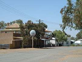 Main street of Tibooburra in Hermitage Parish, looking towards the two storey hotel | |||||||||
|
Hermitage Parish | |||||||||
| Coordinates | 29°25′59″S 142°00′29″E / 29.43306°S 142.00806°ECoordinates: 29°25′59″S 142°00′29″E / 29.43306°S 142.00806°E | ||||||||
| Postcode(s) | 2880 | ||||||||
| Elevation | 183 m (600 ft) | ||||||||
| Location |
| ||||||||
| LGA(s) | Unincorporated Far West Region[1] | ||||||||
| Region | Channel Country | ||||||||
| County | Tongowoko | ||||||||
| State electorate(s) | Barwon | ||||||||
| Federal Division(s) | Parkes[2] | ||||||||
| |||||||||
Hermitage, New South wales, is a civil parish of Tongowoko County, New South Wales.[3] The town of Tibooburra is the only settlement in the parish.[4]
Located at 29°22′57″S 142°01′09″E, the parish is on the traditional lands of Yarli peoples. The Geography, of the parish is mostly the flat, arid landscape of the Channel Country. The parish has a Köppen climate classification of BWh (Hot desert)[5].
The nearest town is Tibooburra
References
- ↑ Tibooburra has a "village council".
- ↑ "Profile of the electoral division of Parkes (NSW)". Australian Electoral Commission. 25 February 2016. Retrieved 12 July 2016.
- ↑ "Tongowoko". Geographical Names Register (GNR) of NSW. Geographical Names Board of New South Wales. Retrieved 4 August 2013.
- ↑ Map of the County of Tongowoko: Western Division, Land District of Willyama.
- ↑ Peel, M. C.; Finlayson, B. L.; McMahon, T. A. (2007). "Updated world map of the Köppen–Geiger climate classification". Hydrol. Earth Syst. Sci. 11: 1633–1644. doi:10.5194/hess-11-1633-2007. ISSN 1027-5606. (direct: Final Revised Paper)
This article is issued from
Wikipedia.
The text is licensed under Creative Commons - Attribution - Sharealike.
Additional terms may apply for the media files.